Showing posts with label Lewis & Clark. Show all posts

Wednesday, March 10, 2021

Last Minute Overnighter - Burro Creek/Bonanza Wash Mining Ruins, Alamo Lake and Maggie Slot Canyon


Lewis & Clark squeezing through Maggie Slot Canyon
The itch to get out and camp is real!  Paul and I were both feeling it.  It's been a rough month, and we have limited time ahead of us for outings, so we've decided to make the most of the last couple weeks before I have surgery to get out, explore, and just play in general!  Unlike our normal pre-planning, Paul and I decided - pretty much the night before, to head up and check out some mining "stuff" we had seen on Google Earth, then go camp on the north side of Alamo Lake.  
Burro Creek - With Water!
Anyone that knows us knows we plan.  Plan, plan, plan.  In fact, the motto of our team (also known as the Dirt Road Duo) is Research, Map, Explore.  So deciding on Friday that we want to go camping the next day, and then deciding on a place and route Friday evening is completely outside our normal.  And then, to be even more different - I let Paul do ALL the planning.  I didn't load the routes in to GaiaGPS to check for other stuff - I was busy with life and Paul planned this amazing weekend - right down to the packing up on Friday after we decided yes, we would go camping.  He did an absolutely amazing job - and we had a fabulous weekend!
Nothing, AZ
Paul looking out the old convenience store in Nothing, AZ
We started our morning out with a get together for a memorial cactus planting for our friend Mike "Duner" Schuette at South Mountain.  This part WAS planned.  For quite some time.  The memorial was touching - Connie came down and brought Mike's mom.  Mike's daughters were there.  It was a beautiful morning, and even the park ranger said that he was amazed at the outpouring of love for Mike...Paul and I left the planting with warm memories of Mike, and again, positive thoughts of friendships formed through commonality with our FJ Cruisers.  

As we headed up the 93 towards Nothing, AZ (our first turn off), I sang my heart out to the radio.  One of the things I love about Paul is our mutual love of the same kinds of music - specifically - his tolerance for bluegrass.  It's not even tolerance - he loves it!  I was raised on bluegrass music, and to this day I adore the sounds of an unamplified banjo, fiddle, or mandolin.  I love the sometimes mournful wails of love gone wrong lyrics (that high lonesome sound!) - I love the old religious mountain music - I love the fun lyrics about moonshine and life.  And we almost always end up listening to bluegrass music on our outings.  
Bobbi Jo at Burro Creek
As we arrived in Nothing, AZ, which has one old, dilapidated building, we stopped to investigate and prepare to off road for a bit.  We decided NOT to air down as we would be coming back down this road and getting back on the 93 to go up to Signal.  Nothing, AZ has, at it's highest population, had 4 people living there.  There was a gas station and a small convenience store - all of which was abandoned by 2005.  The best part of Nothing, AZ, is the town motto, which used to be on the town sign - "Town of Nothing, Arizona - Founded 1977 Elevation 3269 ft - The staunch citizens of Nothing are full of Hope, Faith, and Believe in the work ethic.  Thru the years these dedicated people had faith in Nothing, hoped for Nothing, worked at Nothing, for Nothing."  Good old Nothing, AZ.  All that is left is the sign and the old store, which is quickly falling down... 
We head into the Grayback Mountains from Nothing, AZ north towards Burro Creek.  To the east of us is Bagdad - a huge mining complex.  This area of Arizona, like others, is full of old and new mines and claims.  We follow our route on GaiaGPS very carefully - on a trail that is not much more than a trail.  At times, it seems a bit narrow for a truck.  And then we pop down into the Bonanza Wash and realize that there is another trail in - more like a well graded road.  Leave it up to me and Paul to take the hard line!  As we get closer to Burro Creek where the mining remains are, we start navigating boulders and bigger rocks.  But we make it.  And I start with the "I see things!!!"  We park at the creek.  And Burro Creek is flowing - a lot!  The water is very clear, and we can see the bottom - at the deepest it appears to be about 6 foot deep - but there's water!  In a creek!  In Arizona!  It's like a small miracle.  Ha.  😀
Old mining building at Burro Creek/Bonanza Wash
Old Mining Building at Burro Creek/Bonanza Wash
Overlooking Bonanza Wash from the cabin - Lewis & Clark in the lower right
We park Lewis & Clark and decide to hike up to the large building and mining ruins overlooking Bonanza Wash.  The old building was well built - Paul indicated that the concrete foundations and workings were very professionally formed, and only the wood is rotting away at this time.  Lots of very thick window glass lying around, and the front cover of some sort of engine or generator is lying on the ground.  We then hike further up to what appears to be the mill workings, which were outstanding and worth the hike.  The front cover that we had seen by the large building belonged to a generator up at the mill site.  The insides had been pulled and stripped of the copper - a common site nowadays.  No indication of where any actual mine might be, but there are two large concrete tanks which clearly flowed down to the mill workings.  There is then piping that was laid down towards Burro Creek.  And once we were up at what appeared to be the mill workings, we could see a cabin on the hill on the other side of Bonanza Wash.  The view was spectacular - we could see Burro Creek both directions and again, water in the river was just outstanding!
Mill workings
Generator, minus the copper and door
Generator Door

From the Mill site overlooking Burro Creek
As we slowly moseyed back down to the truck and up the other side of the wash, an absolutely beautiful dilapidated cabin came to view.  This cabin was once something special - a gorgeous stone fireplace, a stone entry way that looked to have possibly been a screened outdoor room at one time, and green painted trim.  I absolutely fell in love with this little cabin.  The view was amazing - it was overlooking Burro Creek and the mountains and was one of the prettiest settings for a cabin I've ever experienced!  I wonder if a woman lived there...it was so lovely and homey that I would suspect that more than a wizened old miner had lived there...
Cabin overlooking Burro Creek and Bonanza Wash
Beautiful stone fireplace in the cabin
After relaxing for a few moments in the shade of this beautiful hideaway, we started back down the trail, got into the Lewis & Clark, and headed out.  The easy road.  Not the hard one.  We arrived back in Nothing, AZ in short order, but we were both really tired and decided to stop and make some coffee with our JetBoil.  And yes, I had coffee.  With lots of sugar and creamer.  But Paul had purchased some new coffee - Death Wish Coffee - the "World's Strongest Coffee."  It wasn't terrible - but then Paul would tell you that I had a dash of coffee with my cream and sugar...but it was definitely full of caffeine.  Within 30 minutes I was bouncing off the walls of the truck and ready for more fun!  We headed northbound on the 93 up to Signal road, where we turned in, aired down, and started our long trek to the north banks of Alamo Lake.  
The Cabin from the  porch
The trek in was uneventful - and we just took took Alamo Rd in to the 15, then followed that to a gorgeous little area by the lake.  There were trees all over in the edges of the lake with lots of ducks.  We set up camp with our brand new 2P Marmot Crane tent and the awesome Exped MegaMat Duo 10 sleeping pad - which was like sleeping on a cloud!  We had bagged dinners and made a fire and watched the sun set and the cows mill around on the ridge above us.  We decided to watch a movie for a bit as I was still hyped up from the coffee.  We settled in to the truck and started to watch the oddest film - so odd we didn't even finish it.  The wind was whipping all around us, and the whole area became creepy as the full moon rose and we could see a cow standing on the ridge in the distance just watching us.  I decided it was time for bed!
Camp Dinner
Camp
The 2P Marmot Crane tent was definitely cozy, but left no room for anything but the Exped Mat, our blankets, pillows and ourselves.  It would be a great little tent for one person, but, well, Paul and I aren't tiny people, so I think in the future we will go back to the 6P Marmot tent.  But the Exped Mat - that was worth every single penny!
Sunrise from the tent
The next morning we woke up and stoked the fire.  We made coffee and tea in the JetBoil and made our bagged meals again, and packed up camp to head out to explore a bit before the 3 hour trek home.  As we made our way out of the valley we were camping in, we decided to head up to Huffman, an odd encampment with tons of buildings - many old.  But it appeared occupied and there were some no trespassing signs on some of the roads (but not all), so we did not venture in.  We also explored Love's Camp - which consisted of several rock lined pathways and numerous foundations.  I've yet to find any history of Huffman or Love's Camp. 
Dragon head in the flames...

 
Alamo Lake from Camp
Alamo Lake from Love's Camp
We then decided to head over to the proper north entrance to Alamo Lake - which was disappointing - it was much prettier where we camped, and then we went to Maggie Slot Canyon.  As we exited the road into the wash and the redrock canyon enveloped us, the stunning beauty of the desert was once again obvious - tall redrocks on either side, some snug squeezes, a beautiful hike down a side slot canyon, and an awesome squeeze through with the Lewis & Clark (as shown half way through the video).  

Maggie Slot Canyon
Me and Paul in the side slot canyon

Lewis and Clark with her flat tire...and the Hi-Lift Jack
After Maggie Slot Canyon, there wasn't much to do except head home - so head home we did.  But not before we had a flat tire and I learned how to use the Hi-Lift Jack!  But it was a beautiful and relaxing weekend - and a much needed escape from the stresses of life.  And HUGE thanks to Paul for all the planning - it was just what I needed!  💙
Me and Paul at the Cabin

Tuesday, January 26, 2021

Death Valley Overland - Part 3 - Viking Mine, Minnietta Cabin & Mine, Ballarat, Claire Camp/Ratcliff Mine and the World Beater Mine Cabin

Lewis & Clark at the Viking Mine Camp - Overlooking the Lower Centennial Flats

It's Wednesday morning - day three of overlanding - no shower for Bobbi and she's starting to feel a bit grimy.  But we slept amazingly well at the Boxcar Cabin with the wood burning stove putting off lots of heat and then the Mr. Buddy Heater, which Paul set up in the middle of the night to make sure we stayed warm.  

Paul and Bobbi Jo - up early at the Viking Mine Camp

We were lazy about waking up, and when we did get up, we were starving - our ever-favorite applewood smoked bacon and eggs for breakfast filled up our stomachs and then we decided to clean up and pack up so we could head out and explore!  We weren't sure where we were planning on spending the next night, so we were free to end up where we ended up - no specific plans and we hoped to make it to our destination early enough to relax and maybe watch a movie tonight.  Specifically we wanted to watch Helter Skelter as we knew we were headed to Barker Ranch on New Year's Eve.  Paul hadn't seen Helter Skelter and I wanted him to watch it before we visited Barker.  

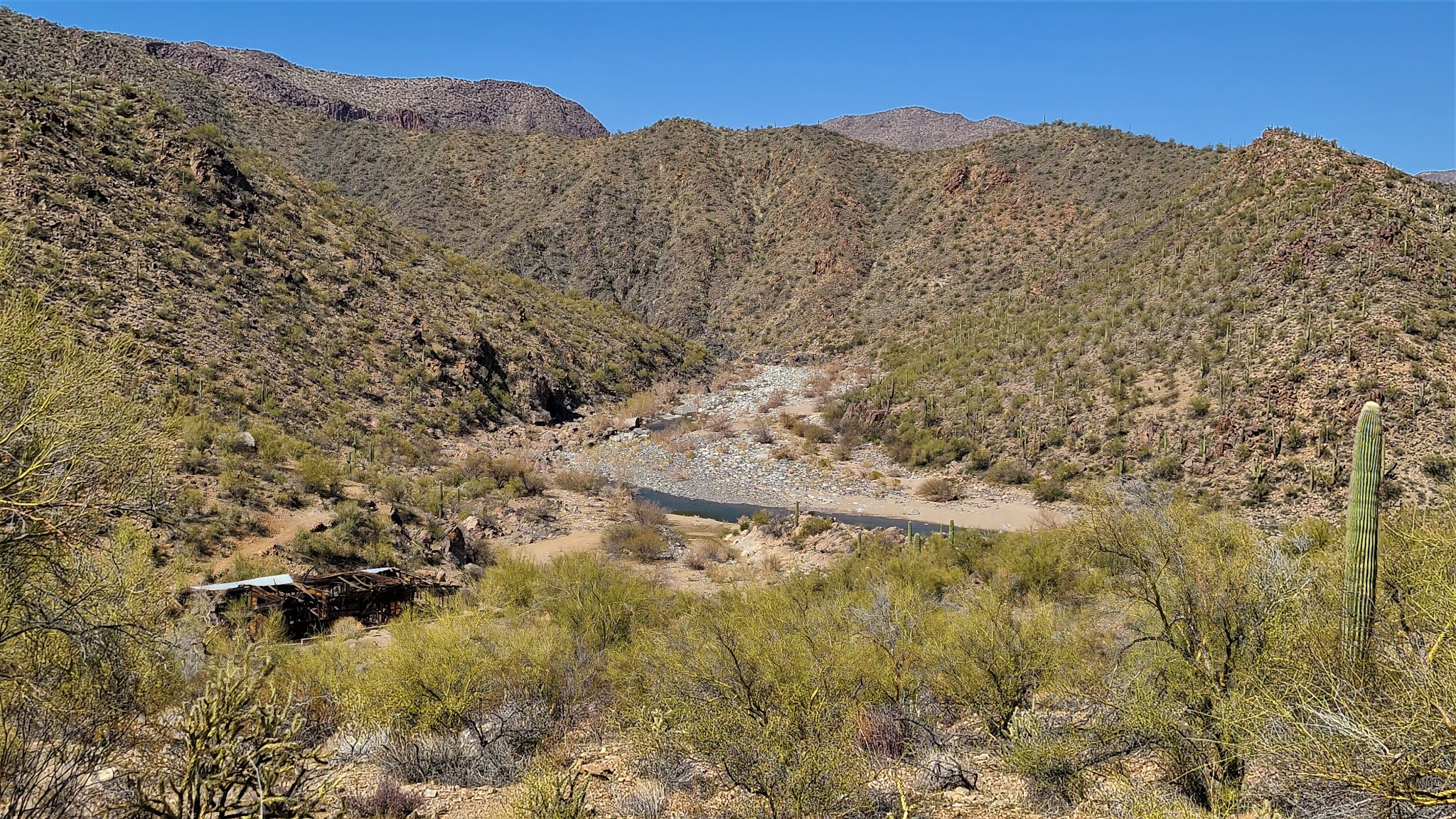
Viking Mine Camp - note the Christmas wreath!

So we left Boxcar Cabin behind and decided to quickly check out the Viking Mine Camp - an abandoned talc mine camp.  As it turned out, it wasn't a quick stop.  You can see the Viking Mine Camp from the 190 - so we were really surprised about the condition it is in.  I've since learned there are volunteers who are attempting to keep the Viking Mine in stable condition.

Viking Mine Camp - Large Building With Multiple Rooms - Wood Shingles for Siding

The Viking Mine Camp is on a small hill overlooking the Lower Centennial Flats.  It was cold but sunny - and a stunning morning to overlook this wide expanse of nothingness.  I have absolutely no history whatsoever on this camp - but there are multiple buildings, and a "fire pit" building with benches that I've since learned was a former garage that caved in.  

Papa Smurf - I Mean Paul - At Viking Camp

We walked around the multiple buildings, and up towards one of the mines, however, we didn't see much up that way, so we turned around and decided to head in towards Panamint Springs again and over towards Ballarat.  There was a cabin we wanted to see on the way...

Little Fixed Wing at Panamint Springs

Back on the 190, we went by a pit toilet maintained by the NPS overlooking Rainbow Canyon, so I begged Paul to stop, and we did.  I mean, I'm doing pretty good with this overlanding thing - but a bathroom is a rare thing - so you must stop when you can!  The NPS is doing a great job during the California shut down of maintaining these pit toilets - they even have lemon scented hand sanitizer in all of them!  

We do one last stop at Panamint Springs, which we know will be the last stop with any semblance of groceries, etc.  I was going to get more eggs, but the truck doesn't come until this afternoon - so no more eggs this trip.  And we are off again...

Panamint Valley Road

We turn down Panamint Valley Road.  This is one of those roads that "goes off into the sunset" - it traverses the Panamint Valley - a large dry lake with occasional salt marshes.  I told Paul on this trip that when I first moved to Arizona from Colorado I thought Arizona was ugly - so brown and beige - nothing beautiful about it.  I've now lived in Arizona for 34 years and I find immense beauty in the desert - and today was one of those days that I found an immense amount of beauty in the desolate desert.  Here we are - just me and Paul - not another soul in sight - enjoying each other's company and the solitude of being offline, unwired and more connected to nature than usual.  What a beautiful way to spend a vacation~~

Minnietta Cabin - note the flag - the cabin is taken

We decide to take a brief detour to check out a cabin we had seen on Google Earth - the Minnietta Cabin and Mine.  As we drive down the 4WD road we pass the mine, and pull up to the Cabin.  The flag is out and there is a truck there, so we know that the cabin is currently taken - the picture here is a good example of how you know if a National Park Service cabin is available for use.  They are always first come, first served, and it is asked that you stay no more than 3 days.  You have to put the flag out, or the cabin is not considered "yours" for the night.  So we did not get to see the inside of Minnietta Cabin, but we did head back down to the Minnietta Mine/Little Mack Mine.  

Minietta Mine/Little Mack Mine

The Minnietta Mine/Little Mack Mine is a lead and silver mine.  It began operations in 1902, and then waqs on and off again until 1915.  In 1924 the mine was reopened and a mill and much of the modern equipment we see today was installed.  It appears the last bucket of ore was shipped out in 1952 - the Minnietta Mine produced roughly $1,000,000.00 in ore (per the National Park Service).  

Paul Being a Kid and Climbing on Things at the Minnietta Mine - This Boy Never Grows Up!

There were plenty of things to see here - the mine shaft up at the top of the hill with cabling and tramways coming down to the chute (which of course, Paul had to climb on - because he's Paul and he can't resist), what looked like an adit that had been collapsed, old building frames, and interesting old machinery.  There was even a geocache that I logged!

Panamint Valley Vistas!  Gorgeous...

We knew we weren't staying here for the night, so we headed back towards Panamint Valley Road, and the views were stunning!  We passed a number of Jeeps on the way who were likely trying to get to Lookout City - we had opted not to attempt that route this trip because we had the trailer and there isn't much to see except foundations.  But Lookout City was the first mining district in the Panamint Valley area!  

Ballarat - Note the Power Wagon on the Left - Supposedly Tex Watson's Escape Vehicle - More on That Later

We were now headed to the infamous Ballarat Ghosttown.  On our way there, we heard a VERY loud fighter jet coming, so we stopped and I jumped out - apparently the nearby base does tons of flights and maneuvers through the Panamint Valley - this thing was SO low - and SOOOO loud!  Any vehicles that were on the road stopped and jumped out.  Lewis and Clark was shaking it was so loud!  The jet buzzed us several more times - it was amazing!  But onward we go...we can't watch fighter jets all day.  (Well, I could...but we had places to go and things to see!!)

The J.B. Foote Foundry Co. Leader Automatic Block Machine

Ballarat is located at the base of the Panamint Mountain Range and began its long and storied existence in 1897 as a supply point for the many mines in the canyons of the Panamint Mountains.  It was named after an Australian gold camp by one of the first residents - Australian immigrant George Riggins.  Ballarat, Australia is where the largest gold nugget in the world was found - weighing in at a whopping 143 pounds.  I guess they thought naming this little town in Panamint Valley Ballarat might bring them good luck...

A Catalog from the J.B. Foote Foundry showing the Block Machine at the Bottom!

Ballarat has had as many as 500 residence, although conditions were harsh - summer highs were often 120 degrees or more, and the winter was bitter cold.  Everything needed for survival - water, timber, food - had to be brought in - but these pioneering residents persevered and Ballarat hung on.  

It is said that Ballarat soon had seven saloons, three hotels, a Wells Fargo station, a post office, a school, a jail and a morgue.  But no church.  This seems to be a recurring theme in a lot of ghosttowns.  Hmmm.  Oh, and they apparently had a "red district" of some kind as well - gotta have those "soiled doves"!  

Old Truck on the Way Up Pleasant Canyon to the Claire Camp

The primary draw for me and Paul was the power wagon that is at Ballarat.  The current resident/owner of Ballarat states that the power wagon was the one that Tex Watson (of the Manson Family) drove out of Barker Ranch when he went on the lam.  I wanted to see this power wagon, as I have read some very detailed and compelling information about it NOT being Tex Watson's power wagon.  But we are now in the early afternoon and are wanting to find a place to rest and relax for the late afternoon, and we knew we would be coming back down this way tomorrow before we headed out to Barker Ranch.  So after listening to the storekeeper tell us all about how Tex Watson left the power wagon there, we asked him if the cabins up at Claire Camp are available to staying in, and he said "they are private, but they don't care if you stay there."  We then asked about Briggs Cabin, which we happened to know had hot running water, and he said that the group of Jeeps that had just left (there were about 12 of them) were headed there, and we weren't likely to get the Briggs Cabin or the Stone Cabin next to it.  

Claire Camp Looking North - Cabin is No Trespassing

So off we went up Pleasant Canyon to go to Claire Camp.  This was an interesting, and wet, trip up into the Panamint Mountain Range.  We drove through lots of long grass and even some cattails while following a little stream up Pleasant Canyon.  Then - all of the sudden - the stream was gone (we had passed the "spring" where it came out of the ground) and we were at Claire Camp.  

Boilers at Claire Camp - Note the Two Crosses Up Top

We got very excited because there is a HUGE cabin at Claire Camp - but unfortunately, despite the size and obvious care taken of the cabin, there are No Trespassing signs on the cabin.  Which means that they do NOT want us staying there.  We decided to poke around the mine area for a few minutes - we knew there was another cabin a little further up and another one beyond that - so we had other options.  But this cabin was nice and had multiple rooms.  We were bummed. 

A Piece of Cut Steel Cabling for a Winch or Tramway at Claire Camp

There was a ton to see - boilers, old winches, old buildings - tons to see.  Again, we knew we were coming out this way and the sun was right in our photos, so we didn't spend a great deal of time as we planned to do so tomorrow morning.  

The Radcliffe/Ratcliff Mine was up the hill to the right, but access was corded off - the trail looked nasty anyway.  Henry Ratcliff began mining here in 1896 - his mine was called the Never Give Up Mine.  By 1905, the Ratcliff Mine has suspended their operations.  In 1930, W.D. Claire purchased the Ratcliff Mine and began to work the tailings - this is when it became Claire Camp.  I've seen posts that there were people living there in 2015, so this area has been worked on and off regularly.  

The Amazing World Beater Cabin - Note the Flag We Put Out

We decided to head out and up the canyon a bit further to find the next cabin - the World Beater Mine Cabin.  It was worth the drive and the wait!

As we pulled around a small switchback, the Cabin came into view - it was a gorgeous looking cabin, and we looked around and didn't see a flag.  Excited, we drove up to it, went inside, and put the flag out!  It was ours for the evening!  Easily the nicest cabin we had seen this trip (and ultimately the entire trip).  There was an outhouse, and a HUGE steel drum stove inside.  This cabin is privately owned, but the owners are gracious enough to allow visitors.  By this time, we are getting chilly, so we start up a fire and begin to unload the truck.  

Our Cots, Sleeping Bags and the Monster Stove at the World Beater Cabin!

Paul and I poked around the area a bit - we noted the rough looking road that leads up to the World Beater Mine (most of which burned down in the 1980's due to vandalism), and some remains from some hunters who had dressed their animals here (a pair of legs left out by the outside fire pit).  There was a sink in the cabin (no running water) that drained to the outside, a lovely patio, and there were even curtains on the windows!  The World Beater Mine shares a similar history with Claire Camp - the original owners worked together on the two mines, and abandoned them at the same time and went in together at the lucrative Skidoo Mine in northern Death Valley.   

Patio at the World Beater Mine - and Paul Making Drinks

Happy in the wait to get to this cabin, I made fried kielbasa and potatoes for dinner - comfort food in our comfortable cabin - and we watch the first half of Helter Skelter (it's more than 3 hours long!) in our surround sound FJ Cruiser!  

Bobbi Relaxing After a Long Day - World Beater Cabin

Tired with full bellies and a nice warm cabin, Paul and I tumbled into our cots late, and finished our day off.  The stove worked a bit too well - we were insanely warm.  But we learned quickly we had to keep a fire going because it was VERY windy and if we didn't keep the fire somewhat stoked, the wind would blow down the chimney and fill up the cabin with smoke.  But it was nice to be overly warm - it was the first time in 4 days!  We slept on and off while enjoying the sound of the wind - and the utter pitch black of the World Beater Mine Cabin at night!  

Paul and Bobbi on the World Beater Cabin Patio During Sunset


Friday, November 13, 2020

Mogollon Rim

Mogollon Rim - Rim Road

Ahh - cool mountain air - camping in Northern Arizona on the Mogollon Rim is an absolute joy! 

Blair Witch Tree
Paul and I have been planning this weekend for a little bit - we wanted to get away to somewhere cold. Somewhere where I didn't have phone service. Somewhere deep in the pines. We chose a favorite place of Paul's up on the Mogollon Rim where he has camped many times before. It's been well over a decade since I've been up on the Rim - I used to go up to Greer in my younger days to stay when I would go skiing at Sunrise - my favorite Arizona ski resort. But it's been a very long time. I've camped up this way before, but it's just not an area of Arizona that I've frequented over the years. 

We loaded up Lewis & Clark and her matching trailer (for sleeping - we were expecting snow) with all the things we thought we would need - and some stuff we probably didn't. On Friday afternoon as soon as Paul got off work, we packed up and left town. There was clearly a storm blowing in, but we beat all the traffic heading North into Payson, stopped for a bite to eat at Sonic in Payson while I told Paul about "historic" Payson, fueled up, hit up the casino to use the bathrooms (eww - they still allow smoking in there), and got back on the road to head out to the Rim Road.

As we headed out of town, it cooled down drastically - there was a great deal of cloud cover and the wind was blowing.  As we turned off on to the Rim Road, it was clear it was going to rain, but we still had about an hour of driving to do to get to where we wanted to be - buried so deep we wouldn't see anyone else out there the entire weekend unless we wanted to!

Bull Elk on Night One
We considered ourselves extremely lucky when we first pulled off the main Rim Road onto FR91 - shortly after pulling off, a GIANT elk bound across the road right in the path of our lights, and stopped about 30 feet into the woods and just looked at us.  We took a few pictures - although none are great - but he was majestic!  He was largest elk we would see all weekend.  Shortly after seeing this magnificent creature, we saw another run across the road far in front of us - we watched his eyes flash at us as he moved through the forest over toward Gentry Ridge.  Two large bull elks in less than 30 minutes - I knew this was a sign of a fabulous weekend!!

As we pulled into the first area we had marked for camping, we realized it was already taken - it was dark, but there was a small camper and a truck parked there.  So we left and went further into the forest and up FR91 to FR40F.  This is where we saw the "Blair Witch" tree - so named because it just looked creepy and out of place.  And because I have a penchant for calling odd things in the forest "Blair Witch" stuff.  Paul had a number of waypoints marked for possible campsites - most of them fairly close to where Sasquatch sightings have been reported.  Paul pulled us into a gorgeous campsite off FR40F, and it is pitch black out.  With all the lights on the truck, we quickly set up camp - and it starts to rain - so we decide to go ahead and jump in the camper and try to go to sleep.  I instantly fell asleep to the soft patter of the rain on the camper shell with the wind blowing through the pines.  Throughout the night the rain got harder and the wind blew louder - but the camper was cozy and warm and I slept fairly well.

Paul on our morning walk
We woke up like clockwork at 4 a.m. (that's when we get up during the week) but we both decided to snooze a bit longer.  At 7 a.m., we both woke up, jumped out of the camper to the stunning beauty of pine trees that were four or more stories tall with trunks I can't wrap my arms around - a light breeze blowing - 41 degrees outside, so it's chilly - but we finished setting up camp, and I made breakfast.  Applewood smoked, thick cut bacon and scrambled eggs with tomatoes, onions and mushrooms.  A high protein (and to be honest, high fat) breakfast to get us through the day - man, nothing smells better than bacon cooking in the woods!  We eat to our heart's content, put everything under the tarp, unhook the camper and decide to go exploring for the day.  First, we walk a long loop around our campsite - maybe a mile or so of just following random roads/trails admiring the patches of aspen trees until we get back to our campsite.  The smell of pine and wet aspen remind me of Colorado...


Bobbi in the Aspen Trees
Now last night when we pulled off the highway onto the Rim Road, the truck started making a squeaky noise.  I thought it was the camper - it sounded like an old creaky truck - but when we parked to set up camp, Paul crawled under the truck and discovered it was a ball joint.  I was worried we shouldn't be doing any bouncing around with the truck - but Paul said we would just watch it.  Once we knew what it was, it became a VERY annoying noise - I think because we both were constantly reminded that Lewis & Clark wasn't feeling her best.  Poor gal - we've put the trucks through more in the last 6 months than I think either of them have done in the last year or two - we go out almost weekly now - but the last thing Paul was wanting to do was replace a ball joint before we totally redo the suspension on her (which he isn't quite ready to do yet - Calamity Jane has LOTS of mods coming up over the next two weeks - so we are focused on her right now - not Lewis & Clark).  

Double Springs Cabin
Anyway - annoying noise continuing as we head North on FR40F, we start out to find all the cabins I had located in the general vicinity.  As we are bouncing through the forest, 4 or 5 elk cows come bounding down the side of the mountain, across the road, and down to the meadow below - it all happened too fast for me to grab the camera - but again - we felt absolutely blessed to have seen more elk!  A sign of a healthy forest and a sign of how deep into the forest we really were...


This person used nails/screws to make his mark in 1984
The first cabin we find is at Double Cabin Springs - and what a gorgeous setting.  The cabin at Double Cabin Springs (just passed Besemer Crossing) has no roof, but clearly has a long history - we spent quite a bit of time reading all the carvings in the wall, admiring the building of the structure (huge hand-hewn logs dove tailed together) and checking out the surrounding area - there is a huge fenced in area that surrounds a bog area and the spring.  We never did find the second cabin - not sure if it even exists any more.  But we bounced along on a gorgeous un-numbered route until we hit the 115 (major graded dirt road) that heads up to O'Haco Lookout Tower and Ranger Cabin.  It isn't currently being used, and is fenced off, but we walked the perimeter fence because it was absolutely gorgeous out - big fluffy clouds in the sky with bright spots of blue showing through - a slight wind - and cold enough to wear our North Face jackets!  


O'Haco Lookout Tower

We took the 115 back down to the Rim Road to head across East Leonard Canyon (which can only be crossed by vehicle in one or two places). We drove for quite a while - stopping periodically to look at the amazing view, and to witness the extreme winds on the top of the Rim!  It was awe-inspiring!

General Springs Cabin


We headed over to the well marked General Springs Cabin.  The General Springs Cabin, which is a two room cabin that you can actually enter, was build in 1918 by Louis Fisher and was used for years as a fire guard station (as were most of the cabins we saw this weekend).  The spring and cabin were named after General George Crook who used the spring while traveling the old Fort Apache-Camp Verde Military Road.  The cabin itself was used well into the 1960's, and in 1989 the Forest Service rehabilitated the cabin for our viewing pleasure.  Paul and I were enthralled with the building of the cabin itself - with the way in which they filled the spaces between the logs with splintered wood, etc.  Just like at Double Cabin Springs.  The General Springs Cabin is a well built and well preserved structure.  You can see that there was, at one time, no roof and it has been added to and preserved. This was the first time we actually physically ran in to more people - we looked around for a bit, admired the cabin, then decided to head down to see about the old Railroad Tunnel.  

Misleading sign No. 1 - my hair is covering
it, but it says the trail is .15 miles - this is after our
hike when I'm slightly irritated about the sign
So back on the Rim Road, Paul and I look at the trailhead sign, which reads "RR Tunnel Tr. No. 390 .15 Miles."  Well - we both took that to mean the Railroad Tunnel was at .15 miles down the trail.  It certainly looked like it from the GaiaGPS app!  Paul asked how I felt (I've been sick) and I told him I could handle .15 miles with no trouble at all - even if it meant scrambling up and down the Rim a bit.  So we headed out.  We didn't realize that THE TRAIL HEAD TO THE TUNNEL was .15 miles down the Colonel Devin Trail 290.  So at .15 miles down the Colonel Devin Trail, it splits.  We knew from GaiaGPS to take the left trail - and low and behold - another sign.  RR Tunnel 390 is a loop trail that is just over a mile long.  Okay - we're only going about 1/3 of the way in - I'm still game, and I wanted to see this tunnel - I mean, if they have all these signs, it must be awesome, right?  

Misleading Sign No. 2 - Colonel Devin Trail
Well, I should have done some research.  We get down trail no. 390 about 1/3 of the way, and there's yet ANOTHER sign tacked to a downed tree that has an arrow and says "Tunnel."  Now - there are other people attempting to go up this steep trail.  The trail is sand and loose duffel bag sized boulders.  So now we're scrambling up the side of the Rim.  Paul looks up, and there are people WAY up almost at the top of the Rim still hiking to the tunnel.  The people in front of us turn around.  We spoke briefly to them - they had seen pictures and knew that the trail got worse the further in we got - treacherous is the word used on a few websites - and the wind - we're in a v-shaped canyon which is funneling wind up to the Rim.  There are gusts that are almost knocking me over, and we still have quite the hike out - all up hill, some of it rock scrambling.  And the clouds are looking ominous, so we decide to turn around and start heading up.  If it rains while we're on the trail, it's going to be really bad - the rocks will be slick and the wind won't help.  It's slow going on the way out - but we made it.  The views were still worth it - although the research I've done since shows that the tunnel may not have been worth it.  

Barbed wire the tree has grown around
The tunnel itself was built by James W. Eddy in 1883, along with a powder house (which I understand is still partially standing).  I've read quite a bit about why they were trying to build this tunnel - but to be honest - it makes no sense to me.  In 1888 the company attempting to drill through the Mogollon Rim went bankrupt and they had only drilled 70 feet into the Rim.  

Back at Lewis & Clark, windblown and a bit tired, we break out the crackers and salami, and we head back along the Rim Road to FR139A to head up to Pinchot Cabin/Guard Station.  

This was a beautiful drive through the forest up towards Pinchot Springs - lots of little trails break off into the forest, but we pushed onward and up to the 95, where we had to park and walk in to the Pinchot Cabin and Pinchot Springs.  It was quite frankly the most beautiful cabin setting - a cabin on the edge of a huge meadow with a creek running nearby - it was gorgeous.  The cabin has been shuttered over and locked up, so we couldn't go inside.  The Pinchot Cabin was original part of the Houston Brothers Ranching outfit - there was another cabin built in 1919 by the forest service, but it is no longer here.  The current cabin was build in the early 1930's by John Sanders.  Paul and I poked around for a bit - it was such a lovely walk in, and such a beautiful setting - but we had another set of cabins to visit and it was getting late...so off we went.

Pinchot Cabin
Back to the Rim Road, and over to FR137, we drove North on yet another well graded dirt road (ball joint still squeaking - so we have the windows up and the radio on - listening to bluegrass as usual!).  When we get to the Buck Springs Cabins, we were surprised because there are two!  The smaller of the two cabins was built sometime before 1923, and the larger one was built in 1946.  There was another small cabin built in 1903, but it is no longer there.  These cabins are still in use today as they house the Forest Service fire crews during the summer to protect the Rim!  

The clouds are again turning dark, and it's late - we want to be back to the campsite before it gets too dark - so we head back down to the Rim and back to our campsite.  We were expecting snow tonight (as per the weather reports we are receiving on the Ham radio) so we wanted to make sure everything was covered and well protected - and I had steaks to make for dinner!

And the steaks were awesome!  I had picked up some sirloin filets from Sprouts, and I cooked them in left over bacon grease and butter - holy cow they were amazing!  I made green beans and corn sautéed in butter and Paul and I had a feast - in the dark and cold, but it was a really satisfying meal at the end of a day of exploring the Rim country and some short but strenuous hiking!  
Buck Springs Cabins with Lewis & Clark

It was cold, pitch black out, and sprinkling rain, but we weren't tired yet (it was only about 6:30), so we jumped in the truck and decided to watch a movie on the tablet we use for GPS guidance - of course Paul has scary movies - so we are watching that.  And every time he turns on the headlights, I fully expect to see Jason or Michael Myers staring at us from the trail...Ha!  

We head to bed, and wake up at 4 a.m. (as per the usual) and I'm cold - and there is snow EVERYWHERE!  So Paul and I jump into Lewis & Clark and we turn on the heat.  But it's uncomfortable and we can't sleep, so we just get warmed up, and head back into the camper with warmer clothes to try and sleep - which we do - for a few more hours.  

Snow!

But when we get up - oh my goodness - the beauty of the snow blanket in the forest is overwhelming.  Paul and I wander around taking pictures - the first snow of the season for us - and honestly, probably the first time I've been in snow for 2 or 3 years...

Camp Breakfast - Snow still on the table

We clear off the stove and the table, and I make fried egg sandwiches with sausage links which we wolf down in the truck with the heat on (it's 27 degrees outside).  I'm totally getting the hang of this camp cooking thing!  I've made three awesome meals this weekend - and I'm pretty happy with this - the last time we went camping we had awful burgers - but Paul said it wasn't my cooking that time - it was just the burgers.  But we will be getting these little steak filets again!  And bacon - everything is better in bacon grease.  Everything.  Including toasting the bagel thins.  LOL

Paul and I pack up the campsite and head out mid-morning and decide to take the "91 Loop."  No ball joint noise to be heard since then...


Icicles on the Snorkel

Well - we got off trail somewhere.  We don't even know where.  Paul kept saying "how can we be off trail when we have GPS?"  I'm saying we were "overlanding" and "exploring."  I still cannot find where we went off trail - we somehow end up on this jeep trail - which Lewis & Clark handles just fine, but again - we cannot find the trail on our GPS nor our topographical maps - all we can see is that we are following the Gentry Ridge - and are headed down to Turkey Creek.  But not on a numbered road.  And we had to stop and winch a couple big tree trunks out of the road - which was awesome for me because I've not been able to work with the winch yet (and one is going on Calamity Jane in the next week or two) - so that was fun for me.  This road had a bunch of spots where I had to get out and walk the "alternate" route - but I had a lot of fun just exploring.  I kept telling Paul it was okay as we were "generally" heading South.  

And then - two elk bound across the road - day three of elk - I don't think I've seen so many elk in the wild since the last time I was in Wyoming - where they are a common sight.  Again - we see them in the middle of absolutely nowhere.  There are no other vehicle tracks in the snow so we know we're the first folks down this unknown trail this morning...

Somewhere off trail near Turkey Creek - stunning landscapes!
Somewhere along the way, the trailer wiring comes unhooked, and breaks - so we have no trailer lights - and we are getting frustrated because the trail keeps turning East and West, but eventually we pop out onto FR115, completely covered in mud and dirt, icicles hanging from Lewis & Clark's snorkel (it's still only 28 degrees outside) - but we then head down to the Rim Road, back on to Highway 260, and head in to Payson, where we fix the trailer, visit some old historic haunts that I've told Paul about, and then head home.

It was a beautiful weekend.  It was cold - which we both really enjoyed - we had good food, Paul had good whiskey, and we had snow!  Another perfect weekend of camping!