My adventures on the backroads of Arizona - visiting ghosttowns, mines, cemeteries, and any other areas of interest in remote areas of Arizona and the surrounding states. In addition, we are underwater explorers, so you may occasionally see underwater explorations being posted as well! Welcome to my fantastic life! My name is Bobbi Jo Claywell, and exploring is our thing!
Lewis & Clark at the Viking Mine Camp - Overlooking the Lower Centennial Flats
It's Wednesday morning - day three of overlanding - no shower for Bobbi and she's starting to feel a bit grimy. But we slept amazingly well at the Boxcar Cabin with the wood burning stove putting off lots of heat and then the Mr. Buddy Heater, which Paul set up in the middle of the night to make sure we stayed warm.
Paul and Bobbi Jo - up early at the Viking Mine Camp
We were lazy about waking up, and when we did get up, we were starving - our ever-favorite applewood smoked bacon and eggs for breakfast filled up our stomachs and then we decided to clean up and pack up so we could head out and explore! We weren't sure where we were planning on spending the next night, so we were free to end up where we ended up - no specific plans and we hoped to make it to our destination early enough to relax and maybe watch a movie tonight. Specifically we wanted to watch Helter Skelter as we knew we were headed to Barker Ranch on New Year's Eve. Paul hadn't seen Helter Skelter and I wanted him to watch it before we visited Barker.
Viking Mine Camp - note the Christmas wreath!
So we left Boxcar Cabin behind and decided to quickly check out the Viking Mine Camp - an abandoned talc mine camp. As it turned out, it wasn't a quick stop. You can see the Viking Mine Camp from the 190 - so we were really surprised about the condition it is in. I've since learned there are volunteers who are attempting to keep the Viking Mine in stable condition.
Viking Mine Camp - Large Building With Multiple Rooms - Wood Shingles for Siding
The Viking Mine Camp is on a small hill overlooking the Lower Centennial Flats. It was cold but sunny - and a stunning morning to overlook this wide expanse of nothingness. I have absolutely no history whatsoever on this camp - but there are multiple buildings, and a "fire pit" building with benches that I've since learned was a former garage that caved in.
Papa Smurf - I Mean Paul - At Viking Camp
We walked around the multiple buildings, and up towards one of the mines, however, we didn't see much up that way, so we turned around and decided to head in towards Panamint Springs again and over towards Ballarat. There was a cabin we wanted to see on the way...
Little Fixed Wing at Panamint Springs
Back on the 190, we went by a pit toilet maintained by the NPS overlooking Rainbow Canyon, so I begged Paul to stop, and we did. I mean, I'm doing pretty good with this overlanding thing - but a bathroom is a rare thing - so you must stop when you can! The NPS is doing a great job during the California shut down of maintaining these pit toilets - they even have lemon scented hand sanitizer in all of them!
We do one last stop at Panamint Springs, which we know will be the last stop with any semblance of groceries, etc. I was going to get more eggs, but the truck doesn't come until this afternoon - so no more eggs this trip. And we are off again...
Panamint Valley Road
We turn down Panamint Valley Road. This is one of those roads that "goes off into the sunset" - it traverses the Panamint Valley - a large dry lake with occasional salt marshes. I told Paul on this trip that when I first moved to Arizona from Colorado I thought Arizona was ugly - so brown and beige - nothing beautiful about it. I've now lived in Arizona for 34 years and I find immense beauty in the desert - and today was one of those days that I found an immense amount of beauty in the desolate desert. Here we are - just me and Paul - not another soul in sight - enjoying each other's company and the solitude of being offline, unwired and more connected to nature than usual. What a beautiful way to spend a vacation~~
Minnietta Cabin - note the flag - the cabin is taken
We decide to take a brief detour to check out a cabin we had seen on Google Earth - the Minnietta Cabin and Mine. As we drive down the 4WD road we pass the mine, and pull up to the Cabin. The flag is out and there is a truck there, so we know that the cabin is currently taken - the picture here is a good example of how you know if a National Park Service cabin is available for use. They are always first come, first served, and it is asked that you stay no more than 3 days. You have to put the flag out, or the cabin is not considered "yours" for the night. So we did not get to see the inside of Minnietta Cabin, but we did head back down to the Minnietta Mine/Little Mack Mine.
Minietta Mine/Little Mack Mine
The Minnietta Mine/Little Mack Mine is a lead and silver mine. It began operations in 1902, and then waqs on and off again until 1915. In 1924 the mine was reopened and a mill and much of the modern equipment we see today was installed. It appears the last bucket of ore was shipped out in 1952 - the Minnietta Mine produced roughly $1,000,000.00 in ore (per the National Park Service).
Paul Being a Kid and Climbing on Things at the Minnietta Mine - This Boy Never Grows Up!
There were plenty of things to see here - the mine shaft up at the top of the hill with cabling and tramways coming down to the chute (which of course, Paul had to climb on - because he's Paul and he can't resist), what looked like an adit that had been collapsed, old building frames, and interesting old machinery. There was even a geocache that I logged!
Panamint Valley Vistas! Gorgeous...
We knew we weren't staying here for the night, so we headed back towards Panamint Valley Road, and the views were stunning! We passed a number of Jeeps on the way who were likely trying to get to Lookout City - we had opted not to attempt that route this trip because we had the trailer and there isn't much to see except foundations. But Lookout City was the first mining district in the Panamint Valley area!
Ballarat - Note the Power Wagon on the Left - Supposedly Tex Watson's Escape Vehicle - More on That Later
We were now headed to the infamous Ballarat Ghosttown. On our way there, we heard a VERY loud fighter jet coming, so we stopped and I jumped out - apparently the nearby base does tons of flights and maneuvers through the Panamint Valley - this thing was SO low - and SOOOO loud! Any vehicles that were on the road stopped and jumped out. Lewis and Clark was shaking it was so loud! The jet buzzed us several more times - it was amazing! But onward we go...we can't watch fighter jets all day. (Well, I could...but we had places to go and things to see!!)
The J.B. Foote Foundry Co. Leader Automatic Block Machine
Ballarat is located at the base of the Panamint Mountain Range and began its long and storied existence in 1897 as a supply point for the many mines in the canyons of the Panamint Mountains. It was named after an Australian gold camp by one of the first residents - Australian immigrant George Riggins. Ballarat, Australia is where the largest gold nugget in the world was found - weighing in at a whopping 143 pounds. I guess they thought naming this little town in Panamint Valley Ballarat might bring them good luck...
A Catalog from the J.B. Foote Foundry showing the Block Machine at the Bottom!
Ballarat has had as many as 500 residence, although conditions were harsh - summer highs were often 120 degrees or more, and the winter was bitter cold. Everything needed for survival - water, timber, food - had to be brought in - but these pioneering residents persevered and Ballarat hung on.
It is said that Ballarat soon had seven saloons, three hotels, a Wells Fargo station, a post office, a school, a jail and a morgue. But no church. This seems to be a recurring theme in a lot of ghosttowns. Hmmm. Oh, and they apparently had a "red district" of some kind as well - gotta have those "soiled doves"!
Old Truck on the Way Up Pleasant Canyon to the Claire Camp
The primary draw for me and Paul was the power wagon that is at Ballarat. The current resident/owner of Ballarat states that the power wagon was the one that Tex Watson (of the Manson Family) drove out of Barker Ranch when he went on the lam. I wanted to see this power wagon, as I have read some very detailed and compelling information about it NOT being Tex Watson's power wagon. But we are now in the early afternoon and are wanting to find a place to rest and relax for the late afternoon, and we knew we would be coming back down this way tomorrow before we headed out to Barker Ranch. So after listening to the storekeeper tell us all about how Tex Watson left the power wagon there, we asked him if the cabins up at Claire Camp are available to staying in, and he said "they are private, but they don't care if you stay there." We then asked about Briggs Cabin, which we happened to know had hot running water, and he said that the group of Jeeps that had just left (there were about 12 of them) were headed there, and we weren't likely to get the Briggs Cabin or the Stone Cabin next to it.
Claire Camp Looking North - Cabin is No Trespassing
So off we went up Pleasant Canyon to go to Claire Camp. This was an interesting, and wet, trip up into the Panamint Mountain Range. We drove through lots of long grass and even some cattails while following a little stream up Pleasant Canyon. Then - all of the sudden - the stream was gone (we had passed the "spring" where it came out of the ground) and we were at Claire Camp.
Boilers at Claire Camp - Note the Two Crosses Up Top
We got very excited because there is a HUGE cabin at Claire Camp - but unfortunately, despite the size and obvious care taken of the cabin, there are No Trespassing signs on the cabin. Which means that they do NOT want us staying there. We decided to poke around the mine area for a few minutes - we knew there was another cabin a little further up and another one beyond that - so we had other options. But this cabin was nice and had multiple rooms. We were bummed.
A Piece of Cut Steel Cabling for a Winch or Tramway at Claire Camp
There was a ton to see - boilers, old winches, old buildings - tons to see. Again, we knew we were coming out this way and the sun was right in our photos, so we didn't spend a great deal of time as we planned to do so tomorrow morning.
The Radcliffe/Ratcliff Mine was up the hill to the right, but access was corded off - the trail looked nasty anyway. Henry Ratcliff began mining here in 1896 - his mine was called the Never Give Up Mine. By 1905, the Ratcliff Mine has suspended their operations. In 1930, W.D. Claire purchased the Ratcliff Mine and began to work the tailings - this is when it became Claire Camp. I've seen posts that there were people living there in 2015, so this area has been worked on and off regularly.
The Amazing World Beater Cabin - Note the Flag We Put Out
We decided to head out and up the canyon a bit further to find the next cabin - the World Beater Mine Cabin. It was worth the drive and the wait!
As we pulled around a small switchback, the Cabin came into view - it was a gorgeous looking cabin, and we looked around and didn't see a flag. Excited, we drove up to it, went inside, and put the flag out! It was ours for the evening! Easily the nicest cabin we had seen this trip (and ultimately the entire trip). There was an outhouse, and a HUGE steel drum stove inside. This cabin is privately owned, but the owners are gracious enough to allow visitors. By this time, we are getting chilly, so we start up a fire and begin to unload the truck.
Our Cots, Sleeping Bags and the Monster Stove at the World Beater Cabin!
Paul and I poked around the area a bit - we noted the rough looking road that leads up to the World Beater Mine (most of which burned down in the 1980's due to vandalism), and some remains from some hunters who had dressed their animals here (a pair of legs left out by the outside fire pit). There was a sink in the cabin (no running water) that drained to the outside, a lovely patio, and there were even curtains on the windows! The World Beater Mine shares a similar history with Claire Camp - the original owners worked together on the two mines, and abandoned them at the same time and went in together at the lucrative Skidoo Mine in northern Death Valley.
Patio at the World Beater Mine - and Paul Making Drinks
Happy in the wait to get to this cabin, I made fried kielbasa and potatoes for dinner - comfort food in our comfortable cabin - and we watch the first half of Helter Skelter (it's more than 3 hours long!) in our surround sound FJ Cruiser!
Bobbi Relaxing After a Long Day - World Beater Cabin
Tired with full bellies and a nice warm cabin, Paul and I tumbled into our cots late, and finished our day off. The stove worked a bit too well - we were insanely warm. But we learned quickly we had to keep a fire going because it was VERY windy and if we didn't keep the fire somewhat stoked, the wind would blow down the chimney and fill up the cabin with smoke. But it was nice to be overly warm - it was the first time in 4 days! We slept on and off while enjoying the sound of the wind - and the utter pitch black of the World Beater Mine Cabin at night!
Paul and Bobbi on the World Beater Cabin Patio During Sunset
"The life of the desert lives only by virtue of adapting itself to the conditions of the desert. Nature does not bend the elements to favor the plants and animals; she makes the plants and animals do the bending."
John C. Van Dyke
The Racetrack Playa Looking South - Death Valley National Park
So we wake up in Lost Burro Gap. It's freezing cold. It snowed for a bit last night, but the fog is gone and the sun is out. We get up and out of the trailer (which is toasty warm thanks to quilts, a down comforter and the Buddy Heater). Waking up after sleeping in the trailer is always a bit of a slow process. We've been sleeping in what is essentially a twin bed, and we aren't spring chickens anymore, so there are creaking joints, achy muscles - but out we tumble to make some coffee/tea and discuss breakfast. I thought for sure we could stoke the fire and get it up and going again, but no such luck. It is completely dead - and we decide not to start another fire just to have to put it out in an hour. So I start up our Coleman camp stove, and used the left over sausage to make sausage patties, fried a couple of eggs, and toasted some bagel thins (what we use for bread when we are camping) and we had sausage and egg sandwiches for breakfast! Man we eat well when we camp!!!
Early Morning - Moon is Still Out - Lost Burro Gap - Our Campsite
We walk around while eating our breakfast sandwiches to keep warm, and mosey back to the campsite to start tearing everything down.
Our set up is very organized - we have bins for everything - comforter and quilt have a bin, pillows go in a bin, we have a camp kitchen bin, we have utensil containers (ammo boxes) that go in the mess bin, we have the "dry goods" bin for food that doesn't need to be refrigerated but needs to be sealed up, and the "booze box" which usually contains a bottle of whiskey (for Paul), a bottle of amaretto (for Bobbi), some sweet and sour mix, and a couple different mixers for Paul's whiskey. Everything has it's place - and we get it all put away and put back in the trailer. We change clothes, wash faces, brush teeth, and we're ready to go. It takes us about 30 minutes - not rushing - to fully tear down camp - this includes unhooking the heater, taking down the stove/oven, unhooking the OxxBoxx (camping Keurig) from the inverter and the truck, and getting everything secured down so nothing breaks. I imagine if we rushed we could tear down in a matter of 10-15 minutes.
Packing Up The Expedition Trailer - All That Is Left are the Cots and Chairs
As we warm up in the truck, we discuss our plans for the day. We still hadn't decided on Lippincott Pass - but we decided not to try it with the trailer. We had found a different pass which was lower in elevation and was mentioned in the Death Valley trail guide as being perfectly doable. Unlike Lippincott Pass which the book briefly mentions as a bad idea...
BUT - before we can do anything - we have to go to the infamous Racetrack Playa.
A couple of rocks at the northern end of the Racetrack Playa
The Racetrack Playa is a dry lake bed. It is famous for it's "sailing stones" or rocks that move - somehow unassisted - across the dry lake bed and leave "trails" or "tracks" in their wake. The northern end of the dry lake bed is only 1.5 inches higher in elevation than the southern end - so it is exceptionally flat. It is full of extremely fine sediment that has washed down from the mountains on the northern end, and during heavy rain storms (very infrequent), the silt is washed across the playa, and the playa itself becomes what is called an endorheic lake. As the water in this "lake" dries, it leaves a very slick mud, which in turn dries and cracks, making the very distinctive hard, cracked surface that is the Racetrack Playa.
Paul and Bobbi Jo at the Racetrack Playa with The Grandstand in the Background
For years and years nobody knew how the stones that are scattered about the Playa moved - what they did know was that they left tracks - or scars - in the mud that could be seen for years after the movement had occurred. It was long thought that when the lake bed was wet/muddy, high winds and extreme cold created a slick environment that allowed for the stones to be pushed about the Playa. It has since been theorized and then proven (in 2014) that when the Playa is a very shallow lake, if the water freezes over night, and the thin veneer of ice breaks, winds (which can be hurricane force in the valley) push the now sliding ice along, and that ice shoves the rocks across the muddy lake bed, leaving tracks. It is a VERY specific set of conditions, however, that make the rocks move. A flooded surface, a thin layer of silt/clay, wind, ice floes and warming temperatures to break up the ice.
The Grandstand at the Racetrack Playa - Death Valley National Park
Paul and I unfortunately did not see any rock trails. We saw lots of rocks. And plenty of vehicle tire marks (which is discouraging as it ruins this very fragile environment). We walked out to the Grandstand and around it looking for rocks with trails. We plan to come back...I now know better where to look...I know the trails are there. I just didn't plan. Next time we will come up early and hopefully go up to the Lippincott Mine and over the pass - which starts at the southern end of the Racetrack Playa.
Lewis & Clark at Teakettle Junction - We Hope for the Last Time...
So off we went back towards Teakettle Junction as we decided to try going up to the Ubehebe (there's that word again!) Talc Mine, then over Harris Pass to head over to the Saline Valley. Up the rough and long road from the Racetrack we went - optimistic that we were going to have a great time going up over Harris pass and coming out on the other side. As we turn back towards Lost Burro Gap (again) at Teakettle Junction, we say goodbye to all the teakettles. Again. Hoping this is the last time we see it this trip. Onward we drive past the turn off to Lost Burro Mine and off we go to try and see the Ubehebe Talc Mine.
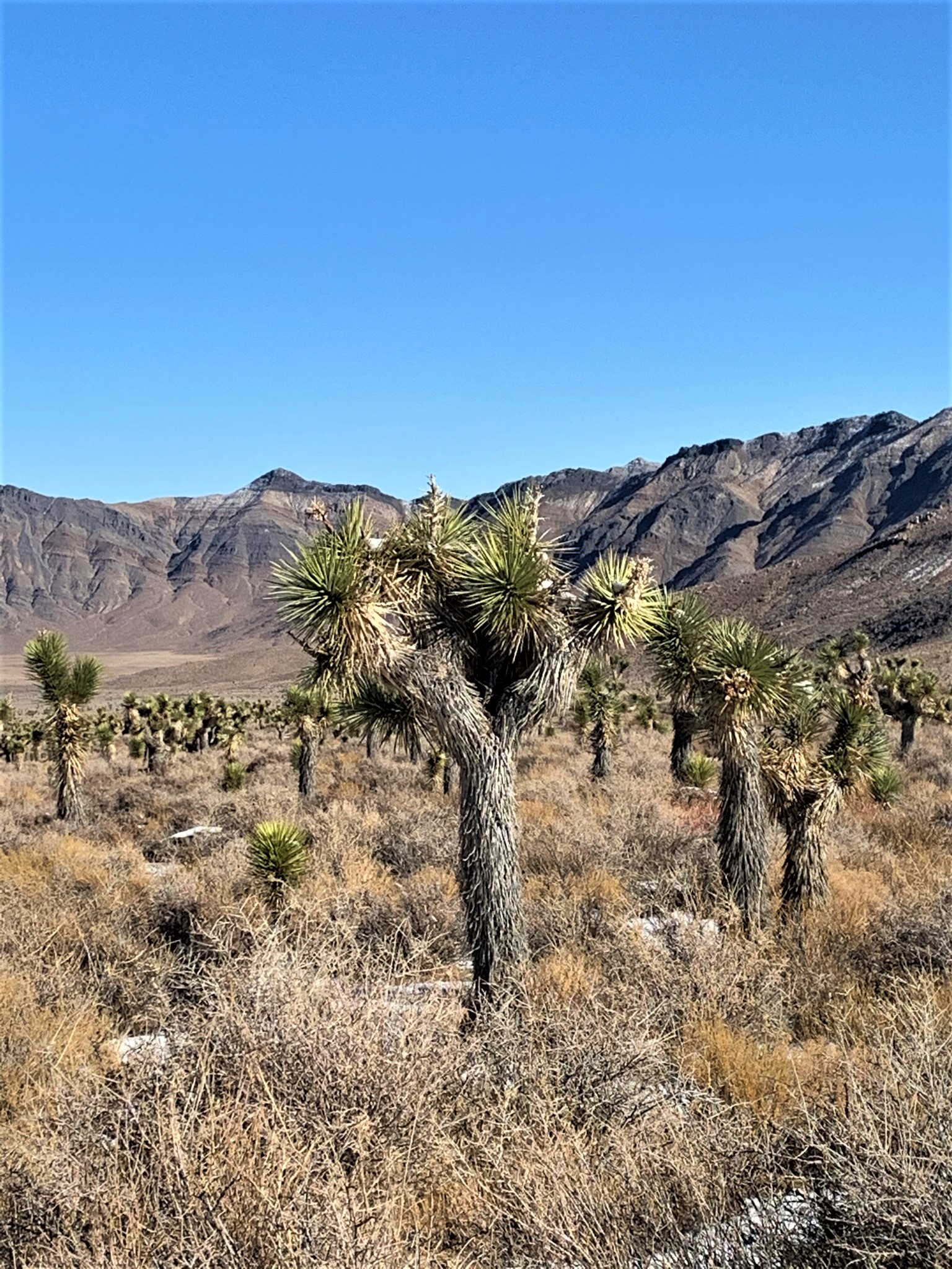
Snow in Hidden Valley and on the Joshua Trees
Driving through the Hidden Valley is interesting. There is a bunch of snow, but not deep. But it clearly had started to melt last night and then froze over night. So it's frozen and icy snow this morning. Because of the melt, there are many areas that are wet and muddy - but nothing Lewis & Clark can't handle. It's also clear this is part of the Joshua Tree forest.
Joshua Trees
Paul and I love Joshua trees. These trees are weird - they remind me of The Lorax and his Truffula Trees (Dr. Seuss). And I love Joshua Tree National Park. But this isn't Joshua Tree National Park, and I'm amazed to see that the Joshua Trees can grow here. I shouldn't be surprised - we have them in certain spots in Arizona too - I just wasn't expecting them. And with snow too! Paul and I are delighted to find this little Joshua Tree forest inside of Death Valley. It was the only place on our entire trip we saw them.
As we turn off to go up to the Ubehebe Talc Mine (UBEHEBE!!), the road is frozen and snow covered. There are tracks in the snow, but they are frozen into the snow. So it appears the Jeeps that went by our campsite last night came up here when the snow was still fresh. As Paul and I begin the slow climb to the Talc Mine, the Expedition Trailer starts sliding around so we stop for a moment. And trying to get going again while pulling the Expedition Trailer proves to be difficult and now the FJ is sliding around on the ice. As Paul and I stop to assess the situation, and we see that we are going to be on a steep shelf road, we decide this is maybe NOT the time to test out Lewis & Clark pulling a trailer up a steep incline on a shelf road. Paul very carefully backs down the 200 or so feet we've already started up, and I jump out towards the bottom to guide him into a spot where we can turn around. It's cold, and the snow is several inches deep, but we get turned around without incident and we head back to the main road so that we can start our climb towards Harris Pass.
Harris Pass - on the Way Back Down
Harris Pass doesn't look bad from the road. It's definitely a bit steep, but the road is wide and the road is short (less than 3 miles). There's a cool cabin to see up top too! As we start up the Pass, the snow is getting deeper, but there are still tracks from last night's Jeep folks (at least I assume they are from last night - first, we haven't seen one single soul today and second, the tracks are frozen hard). So up we go - meandering around the little hills, then we come to the last bit of steep incline. We have a tight switch back, but Paul manages it like a champ, and then the entire truck and trailer starts sliding into the rut next to the mountain. And the tires are spinning. Paul jumps out of the truck and almost falls due to the ice we are currently on. And even Paul, who is fearless (in my opinion) says maybe this isn't a good idea. But we are just up from a switch back with no real way to turn around. What are we going to do?
Harris Pass on the way up
Paul wants me to jump out of the truck and help guide him backwards into the switchback where it appears we can maybe back up the Expedition Trailer into the "v" of the switchback, and then head back out. I can't jump out of my side because it's up against the mountain - I can't even fully open my door. So I climb over the driver's side, promptly get out - Paul tells me to be careful and not to slip - and I head to the front of Lewis & Clark, and my legs promptly slide out from under me. I grab the bull bar and hold on for dear life...I get myself back up, and tell Paul to go ahead. Now - Paul doesn't know this part - but I basically just held on to the bull bar and let him slide me down with the truck. It was kind of fun. Until we got to the "v" of the switchback. Then it was a million-point turn while we got where we could drive back out of Harris Pass. Then back out to Hidden Valley, out through the Joshua Trees, and back to Teakettle Junction. Yet again. But this time we said our final farewell to this area...
We aren't overly happy about the change in our plans because we are running low on fuel and are hoping not to break into our spare fuel on the roof - but we have an 80 mile drive back to Stovepipe Well to get fuel. We are disappointed because we couldn't make it over the mountains into the Saline Valley, but we chose safety, and Paul chose my sanity - because to be honest - my anxiety level would have been through the roof trying either pass. I trust Paul and his driving implicitly (although I freak out a lot, he has never once put me in harm's way on or off the trail) - but if Paul says it isn't a good idea - there is no way in all of God's beautiful green Earth am I going to push him to try it.
So back past the Ubehebe Crater (UBEHEBE!!!), past the Grapevine ranger station, past the sand dunes and over to Stovepipe Well. We are fairly quiet on this drive, contemplating what we are going to do. At Stovepipe I run in to the restroom while Paul fills up the tank, and I come out and he has a plan! We're going to drive through the park - past Panamint Springs, and go to Boxcar Cabin from the South! Yay!! We have a plan. We are back on track and have a goal. We are just hoping to make it to Boxcar Cabin before someone else claims it - because if we don't, we're sleeping in the Expedition Trailer again! Haha
Our fancy new window...note the orange tape on the side - the window latch broke too!
As we are driving to Panamint Springs, I turn around in the passenger seat to get snacks and drinks and I look out the rear window. One of the Expedition Trailer windows is smashed. I gasp, and tell Paul the window is broken. We pull over into Panamint Springs and survey the damage. It's clear a rock flew up and busted the window out. There is glass EVERYWHERE. And a huge hole in our trailer window. This isn't going to work - especially if we need to sleep in it tonight. So I go into the Panamint General Store, and the nice young men there provide me with some cardboard and duct tape (white too!). We doctor up the window, and start back on our trip. Paul is getting a bit discouraged because nothing is going right, and we are both concerned about the Boxcar Cabin being taken now.
As we drive through Rainbow Canyon - which is gorgeous - we discuss what we are going to do if the cabin is already being used - but we turn off onto the Saline Valley road, and we head up towards the Cabin, and NOBODY IS THERE!! No cars in sight, and the flag isn't flying (you put a flag out if you are taking the Cabin for the night). We are SO relieved and SO excited! As we pull up in front of the cabin, Paul and I both gasp out of shock because we see this....
Super creepy...
Someone having some fun. At our expense - but we're okay with it. This little cabin is darling. It's small, two rooms - but cozy, and it has a fire place. Something is finally going our way today!
Boxcar Cabin Sign
Paul gets a little fire going to warm me up, and we bring in the chairs and cots and set them up for sleeping. I'm setting up the kitchen to make goulash for dinner while Paul cleans the rest of the glass out of the Expedition Trailer.
Lewis & Clark, the Expedition Trailer, and The Boxcar Cabin - Our Home for the Night
The Boxcar (or Buckhorn) Cabin is part of the BLM's (Bureau of Land Management's) former Adopt-A-Cabin program. Volunteers kept the cabin in good repair and people were invited to use it on a first come, first served basis. You were only asked to leave the cabin as good as or better than you found it. The Boxcar Cabin is a former railcar turned cabin. Not much is known about it - an old miner named Crutch Bill lived in it in the 80's and in 1958 a prospector named William Carpenter filed the Buckhorn Claims - which is likely when this cabin was placed here.
Bobbi Making Dinner in the Boxcar Cabin
Paul has some of his own history with the Boxcar Cabin. Back on New Year's Eve, 2015, Paul and his best friend, Mike "Duner" Schuette and Duner's wife Connie were taking a similar trip around Death Valley. They camped at the Boxcar Cabin, although Paul slept inside and Mike and Connie camped in their rooftop tent. These memories are bittersweet - I knew Duner from a few runs done with Paul (and at least one without Paul), but Duner passed away in November of 2017. Duner was always super-kind to me, and never let me lag behind, and was very encouraging when I was very new and green to off-roading. He was Paul's exploration buddy and they off-roaded together all the time!
While exploring the cabin and reading all the signatures, Paul found this...
Paul's inscription from 2015 with Mike and Connie
Paul and I reminisced about Mike, about the trail runs, and about their time here in 2015 while we had our romantic one pot dinner of goulash. We were one day off of being exactly 5 years from when he was there before. Paul signed for us, and indicated that Mike is missed...it was a heartfelt moment, and a good memory to leave.
Candlelit Dinner for Two
We had full bellies, and we had a warm and cozy cabin for the night. We expected to get an excellent night's sleep after two nights in the Expedition Trailer - the temperature outside would drop below freezing again tonight...but we were good.
Sleeping Arrangements in the Boxcar Cabin
As the sun set on our "day of everything going wrong" - we decided it wasn't so horrible after all. Yeah, some stuff had gone wrong - but we got the Boxcar Cabin, we were warm and cozy in our memories of good friends - and we were doing what we both loved - exploring!
Revised 2020 Inscription Which Includes Me, and a Tribute to Duner
Night One at the Bonnie Claire - Outside of Death Valley National Park
The day had come! We were heading off on a week long trip to Death Valley - camping in the trailer and in random Park Service or privately owned cabins on a first come first served basis! I've really been looking forward to this trip because I won't have phone service. Pretty much at all. As it turned out, even when service became available at the end - I didn't have it (figures - iPhone) - but that is for the end.
I'm going to break this trip up into multiple posts - we saw and did way too much to put it all in one!
So - Sunday morning - Lewis & Clark and the Expedition Trailer - we are ready to head out! We grab Paul's son and head to Village Inn for a good and nourishing breakfast - drop off the kiddo at his mom's, and off Paul and I go.
Paul and I aren't fond of driving on the interstate (because it's boring) - so we decided to take a round-about way to Beatty, Nevada - the town closest to where we are headed for our first night - which is the Bonnie Claire mine. Off we head to Vicksburg Arizona - where I keep telling Paul about some of the best pies I've ever had at the KofA Cafe. I've been up the Vicksburg/Bouse Road before and stopped several times at the Cafe. Well - the KofA Cafe is closed. I don't know when. But it's closed. Broken windows, etc., although the tables are still set with a thick film of dust and grime on them - I mean, mustard and ketchup with silverware, napkins, salt and pepper on every single table. One more casualty of Covid-19, I assume. And a sad one at that...
Lewis & Clark With the Expedition Trailer at the KofA Cafe
As Paul and I poked around and wonder what happened, lots of trucks drove by and I remembered that the bulk of the clientele here was truckers. Sad that there weren't enough people stopping to keep this small cafe in business.
As we head North yet again, we pass through Bouse (where we stop at the Dollar General to pick up towels in case we can get into the hot springs) and we talk about our exploits to Swansea (where we are NOT going today) and all the places we have visited separately and the places we plan to visit together!
We continue on the road into Parker and we are now turning onto a road I've never been on, but Paul has. We are officially heading in to Las Vegas through Searchlight (don't blink!), and the road is almost as boring as driving on the interstate. In Las Vegas, we decided to get some good burgers, but are trying to avoid casinos at all cost - so we end up at a Fat Burger in a not-so-nice neighborhood. But the burgers and fries were really good, and they had parking for Lewis & Clark and the Expedition Trailer.
Sunset Over Toiyabe National Park
Full of really good burgers, caffeinated for the last leg of our drive, and ready to start our adventure, we head out of Las Vegas towards Beatty, Nevada. As the sun set through the Spring Mountains in Toiyabe National Park, the sunset was outstanding. We watched the temperature get lower and lower - and the clouds get heavier and heavier. Then the weather app said something it hadn't said for the last two weeks. Heavy chance of rain. Figures. Last time we took the Expedition Trailer with us, it rained. Then snowed. Well - it just says rain. No snow, right?
Bonnie Claire at Night
We cruised through Beatty in the dark, see the turn off to Death Valley that we will take in the morning, and drive 30 minutes more up the road to the turn off to Bonnie Claire - which is actually the turn off to Scotty's Castle, but Scotty's Castle has been closed since 2015 due to a massive flood which ripped through the valley and piled mud all up in the Castle. It is thought it will be closed through at least 2022, if not longer. We were bummed because the last time Paul made this trip he couldn't see it either.
Applewood Smoked Bacon
But Bonnie Claire was spooky and beautiful at night. There was a full moon, but with the clouds rolling in, everything took on a haunted feel. I hadn't slept well the night before due to excitement (that's my "m/o" before a trip), had been on the road all day, and it was cold - so we decided to turn in once we got camp all set up. It was the first night I had ever spent in a ghosttown - and with the full moon and the cold, it was an oddly quiet and creepy experience - I loved it!
We woke up on our official "Day 1", and it was cold - and spitting snow!!! SNOW!!! We set up our camp kitchen (our Classic Coleman Propane Stove) with our OXX Heavy Duty Coffeeboxx (hey - we gotta have our creature comforts!) and got out our recently seasoned (by my awesome brother) Lodge cast iron skillet, and made BACON and eggs. I've come to love cooking on this little camp stove - something I never though I would enjoy - and Paul has been very gracious in complementing my cooking (although I don't think it is half bad either!). And this trip, we even have a vintage Coleman Oven! You'll hear about that a little later...
Scrambled Eggs with Tomatoes, Onions and Mushrooms
Anyway - cleaning up the skillet is a breeze - wipe it out with a papertowel and voila! You're done. I save the bacon grease because I use it for everything we are cooking during the week - so into the little metal Stanley cup it goes, and into the fridge. We tear down camp because it's now snowing harder and and the clouds are really, really low. We want an opportunity to explore Bonnie Claire before we head out, but need to be ready to jump in the truck if it starts dumping sleet.
After everything is packed up, we head over to the Bonnie Claire buildings. The Bonnie Claire is a small settlement - settled in 1906, but first founded in the 1880's when a stamp mill was built nearby. The main source of income for Bonnie Claire was the Bonnie Clare Bullfrog Mining Company and the Bullfrog-Goldfield Railroad, which ran ore in for milling at Thorp's Well where the stamp mill was built. Once the Bullfrog-Goldfield Railroad folded in 1928, Bonnie Claire was essentially no more. From 1940 to 1954 there was a short revival to rework the tailings piles (not uncommon out here in the Southwest). Bonnie Claire is also famous for being the railroad station for the initial building of Scotty's Castle, some 20 miles away.
The Bonnie Claire mine workings and Huson House
The house in these pictures belonged to a local miner - Victor Huson - who lived here in the 1950's with his wife, Mellie. Mr. Huson died in 1961 and is buried in nearby Beatty (not the Bonnie Claire cemetery), and Mellie moved to Las Vegas.
Across the road is, what most people refer to as, the Bonnie Claire Mine. However, it is actually the Lippincott Smelter and has been closed and fenced off due to vandalism. It is clearly also rapidly declining and will soon be nothing but a pile of rotting timbers and stones...
Angel's Ladies Brothel Sign and Wrecked Airplane
As we decided to head out from Bonnie Claire and down towards Beatty to enter Death Valley National Park, we stopped at a roadside "attraction" that I had seen online and I desperately wanted a picture of. The Angel's Ladies Brothel sign. There is also an old wrecked airplane there.
Angel's Ladies is, obviously, an old Nevada Brothel (Prostitution is legal in certain parts of Nevada). The airplane, which seems an odd addition to a brothel, is the result of a "deal" which the owner had offered in 1978 - if you parachuted out of their plane and landed perfectly on an old mattress set out in the desert, you could get yourself a free night with the lady of your choice.
Sounds like a great time, right? Well, unfortunately, the inexperienced pilot was mildly distracted by the scantily clad "women of the night" and, in conjunction with some heavy cross winds, managed to crash the airplane into the desert (everyone survived). The owners decided to leave it as an attraction. Mack and Angel Moore (self proclaimed Christian fundamentalist swingers) had purchased the brothel in 1997, and it has been closed since August of 2014. There are still buildings up the road, but all is marked private property and we did not venture up there.
Lewis & Clark in front of the old boxcar at Rhyolite
Now it is time to get serious about our trip - we are headed in to Death Valley - it is no longer snowing, but more like sleet coming down on us - and we are going to take a quick trip through Rhyolite then on to Titus Canyon - the first off road adventure of Day 1.
Rhyolite - anyone who knows about ghosttowns knows about Rhyolite. Paul missed it last time he came through here - but we were determined to go see it. Unfortunately, Rhyolite was overrun with tourists in their little passenger cars (we took the 4 wheel drive road in, we later discovered there is a paved road coming in from the main road). Paul and I were both disappointed and did not stay very long. They have path ways and interpretative signs along the way.
Cook Bank Building
Rhyolite began around 1905 around a gold rush in the area. Rhyolite was in a sheltered basin, which made for an excellent town site, and the population steadily grew to 5000 in 1908. In 1906 after the big San Francisco earthquake and the financial panic of 1907, Rhyolite began a steady and fast decline. By 1911 the Montgomery Shoshone Mine (who employed most of the town's people) closed. By 1920, Rhyolite's population was almost 0. The ruins of Rhyolite were well protected for decades, and have served as backdrops for many movies. The Ruins of the Cook Bank Buildings are infamous - and we stopped to take a photo of those, then moved on to the Goldwell Open Air Museum, which we found much more fascinating!
The Last Supper
The Goldwell Open Air Museum is found on private property just outside Rhyolite. In this open air museum is the 1985 air installation by Belgian sculptor Albert Szukalski called "The Last Supper." This sculpture is a set of ghostly white figurines set to look similar to Da Vinci's Last Supper painting.
Also at the Open Air Museum is "Lady Desert: the Venus of Nevada." It was built in 1992 by Belgian artist Dr. Hugo Heyrman. Paul and I called her the naked lego girl...but whatever. Haha.
Lego Girl, or Lady Desert
Last but not least, there is a third ghostly draped sculpture called Ghost Rider, also done by Szukalski. Paul and I enjoyed walking around this area, even in the sleet and cold, and found much amusement in the sculptural art. Note the bright orange beanie I'm wearing in the photo - Paul and I decided this was so he wouldn't lose me on the trip. Hahaha (Also, I couldn't find my black and white one with the pompom, which magically appeared as soon as we got home).
Paul and I opted to check out the Rhyolite Cemetery on the way out - although we didn't find anything overly notable or old, and the snow was really coming down at this point, so off we went to officially enter Death Valley National Park and start our trek through Titus canyon.
AZBackRoadsGirl and the Ghost Rider
So out we head, and turn off to enter Titus Canyon. Paul didn't do Titus Canyon last time he was here (more on Paul's last trip here in the coming days), so he really wanted to take this side trip into Death Valley. We pulled off the road in the snow/sleet, and start airing down the tires. As we are airing down the tires, two park rangers come flying in and speed up to the sign, which they promptly turn around and now Titus Canyon is closed. As I'm speaking to the Park Ranger, she said we definitely have the vehicle to handle it, however, because there has been absolutely no moisture since March, they are unsure of the trail ahead and are forcing us to turn around. I asked about Lippincott Pass - she said "have you done Lippincott?" I responded with a yes (as Paul had done it several years ago), and she said "I wouldn't do it if it were me."
Looking North to the Grapevine Mountains from Historic Stovepipe Wells - Storm Clouds are Rolling In
Disappointed, we start to air back up the tires because we now have a 50 mile drive in to Stovepipe Wells to figure out what we want to do. As we are airing up, a Tacoma comes back out (note that Titus Canyon is one way, so they are now going the wrong way) - they stop to tell us that they almost went over the canyon side and that we had best not head up that way because it was closed and there was a Park Ranger up ahead stopping anyone coming in. This confirmed our decision not to try and "sneak" in to Titus Canyon.
Me and Paul at Stovepipe Wells Outside the Sand Dunes
Historic Stovepipe Wells - Capped Water Pipe
As we drove the long haul into Stovepipe Wells, and descended in elevation, the snow stopped and it got warmer. We discussed whether or not we wanted to do Lippincott. Paul thought we should try it, and I just wasn't sure. We still had a heck of a long drive just to get to the Racetrack Playa, which starts Lippincott. And all the Death Valley books say Lippincott is "rough and dangerous." Now, Paul has done it - but not with a trailer in tow, and not in snow. Although he did do it at night. But we decide to top off in Stovepipe Wells and head up and stop at Ubehebe Crater (not originally on our plans), over to Lost Burro Mine, and then if it isn't dark or getting dark, we will head off to the infamous Racetrack. We'll decide on Lippincott then...
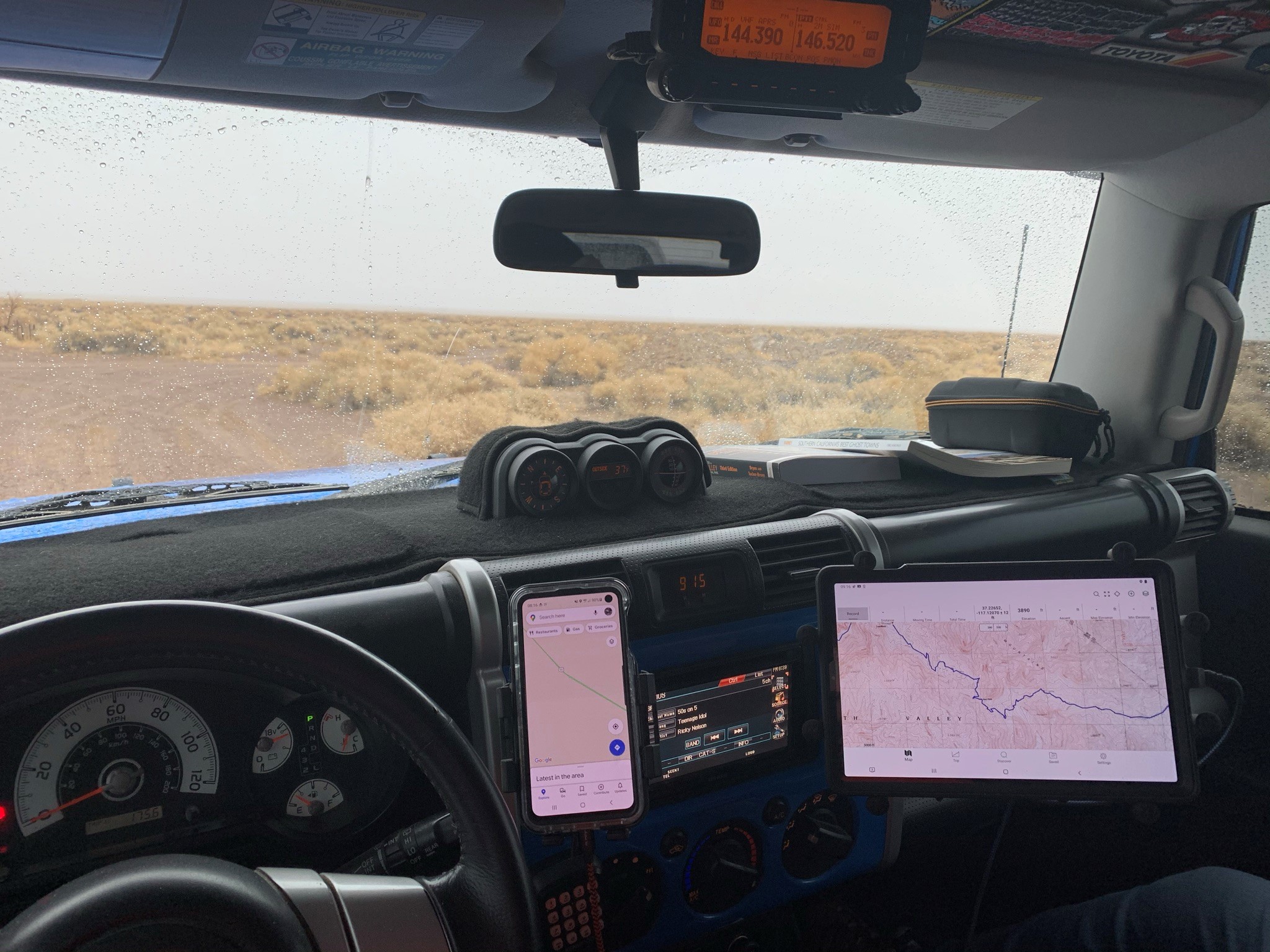
Our In-Truck Overlanding Setup - Ham Radio, Tablet with GaiaGPS, and GaiaGPS on both phones, in case.
At Stovepipe Wells, we topped off on fuel, got our official Death Valley patches (ask us sometime about our patches that we put on our headliners), jumped back in, and started back towards Ubehebe Crater - a 60+ mile drive North into the park. On the way, I see "Historic Stovepipe Wells" on the topographical map along with a "grave" indication (we use GaiaGPS, by the way - check out our very cool in-truck set up!). We decide to stop and take a look as we aren't sure if we will be back this way or not.
So down the little off-shoot we go - a well graded dirt road - to a monument marker. This monument marker explains that this is the site of the original waterhole - the only one in the sand dunes area of Death Valley - and that a length of stovepipe was placed in the watering hole so that people could see it from a distance. It is at less than 10 feet above sea level and it is a California registered historical landmark.
Grave of Val Nolan
The grave is that of miner Val Nolan, who died "from the elements" in August of 1931 and was found and buried on November 6, 1931. He was last seen alive in Beatty, Nevada. Proof of the harsh climate that is Death Valley. Scorching heat in the summer with little to no water, and blistering cold in the winter. It's no wonder the pioneers, when leaving the Panamint Valley area in 1850 said "goodbye Death Valley..." - and hence the name.
We leave Historic Stovepipe Wells and head towards Ubehebe Crater. I just like the word Ubehebe. There's a Little Hebe crater too! But Ubehebe is more fun to say. Ubehebe. Just say it - it's fun!
Ubehebe Crater is a large volcanic crater that is 600 feet deep and half a mile across. It was created when hot magma from inside the Earth's core rose up and reached ground water, causing a massive steam and gas explosion. It's possible that Ubehebe Crater was formed as recently as 300 years ago - but take a look at Google Earth around Ubehebe. There are TONS of craters - you will see small clusters of them all over this area. But Ubehebe is the biggest. And the most fun to say!! UBEHEBE!!!
Paul at Ubehebe Crater
And now begins the washboard road - Paul had warned me about this. We aired down our tires but it was still VERY washboard. We saw passenger cars doing this - in fact, we saw a Mustang GT out on this mess. Ridiculous. But we bounced along with the intentions of stopping at the Lost Burro Mine along the way. After a VERY long drive on the washboard (some 21 miles, I believe), we stopped at the infamous Teakettle Junction.
Teakettle Junction, Death Valley
Nobody is 100% certain how Teakettle Junction exactly came to be, but it is theorized that the placing of a Teakettle at the Junction once indicated that there was water nearby. Either way, it's a very amusing little place literally in the middle of nowhere where people leave kettles and take kettles to leave their mark in Death Valley. It's said to bring good luck if you inscribe your kettle and leave it. The park rangers periodically "cull" the teakettle herd, but state that most of the old kettles get removed by visitors, and due to the "leave a kettle take a kettle" - it doesn't have to happen often. Paul and I read the inscriptions on quite a few of the kettles, and most appeared to be from 2020, so I'm guessing they "cull the herd" more often than they let on...
A Tiny Little Teakettle
As we started to realize we were not likely to make it to the Racetrack Playa today, Paul and I started watching for a good camp spot. We headed in towards the center of the park to go check out the Lost Burro Mine. As we drove through Lost Burro Gap, we found the perfect spot to camp, and hoped it wouldn't be taken when we came back out. California is currently "closed" due to Covid, so we cannot camp in any designated camp areas, therefore we had to find places that fall within the guidelines of camping in Death Valley (only so many feet off the main road, away from water sources, etc). This little spot was perfect - surrounded by mountains to protect us from the wind, off the main road, but not far, and out of the way of other travelers! So we forged on towards Lost Burro Mine so we could get back to our hopeful spot!
As we drove in towards the Lost Burro Mine (quite possibly the only spot we put the truck into 4wd), we came upon the cabin - and I did my usual "Paul - I see things!!! I see THINGS!" I don't know what my obsession is with old pioneer cabins and mines, but I do love them - but what I love most is driving along and seeing a rooftop or a headframe poking up from behind a hill. So we came upon the Lost Burro Cabin and mine. The Cabin is still usable - persons could camp up here and utilize the cabin for shelter. There are lots and lots of cabins within Death Valley, as well as many other National Parks, that are maintained by the National Park Service for the use of visitors - be they hikers, backpackers, off road warriors, horseback riders, or the like. They are always first come, first served, and you are expected to leave the cabins in as good of shape, if not better, than when you left.
Lost Burro Cabin
The Lost Burro Mine cabin was not a cabin we necessarily wanted to stay in, but it was interesting nonetheless to visit. The Lost Burro Mine was accidentally discovered in 1907 by Bert Shivley as he was trying to find his lost burros. There was gold just laying on the ground, so he filed claims and started mining. The mine changed hands many times throughout the years, and in 1970 W.C. Thompson became the sole owner and worked the mine on and off for the next few years.
The Lost Burro Mine Mill Ruins
Along with the main cabin, there is a "Cousin Jack" cabin (a small stone and dugout style cabin), an outhouse, and the mine with the mill ruins. There are artifacts all over inside the cabin, as well as lying scattered about the little valley. Due to the remote nature of the Lost Burro Mine, things are surprisingly intact and well preserved. Paul and I poked around for a bit, then decided it was getting really cold and we wanted to get to a place where we could set up camp and relax for a bit. So back towards the Lost Burro Gap we went in hopes that our little campsite would still be available.
AZBackRoadsGirl Making Stuffed Mushrooms
As we pulled through the Lost Burro Gap, there wasn't a soul in sight, and we were relieved to see the perfect campsite still available! We pulled Lewis & Clark through so as to protect the other side of our little camp area, and Paul immediately pulled out the Big Buddy Heater from Mr. Heater because it had started to rain and sleet again, and I was getting really cold. We got the camper set up for sleeping, started a small fire, and set up the camp kitchen. Tonight I was going to use our new-to-us 1971 vintage Coleman oven! This amazing little contraption harnesses the heat from one burner and disperses it into a metal box, which, when not in use, folds up flat. There's even a little thermometer on the front!
Our Vintage 1971 Coleman Camp Oven
Tonight's dinner would be sirloin steaks from Sprouts and stuffed baby bella mushrooms! So we set up the cute little Coleman oven, which sits over one of the Coleman stove burners, and let it begin to heat up while I cooked up some sausage. I mixed the sausage with cream cheese and stuffed the mushroom caps. Into a small pie tin they went with a small bit of bacon grease, and into the Coleman oven. As we let the stuffed mushrooms cook, I seasoned the sirloins with McCormick's Montreal Steak Seasoning, melted a little bit of bacon fat in the pan, and cooked up the sirloins. Paul likes his steaks much bluer than I do, so mine get cut up to cook a bit more. We watched the Coleman stove, which wasn't heating like we had hoped (didn't realize we were running low on propane), so took the mushrooms out, put them directly on the burner on low with some foil over the top - and everything came together right at the end.
Stuffed Mushrooms and Sirloin by the Fire
Dinner was amazing. It had been a long day and we had skipped lunch. We sat next to the fire, Paul with his whiskey, me with my amaretto sour, and enjoyed a leisurely dinner as the rain stopped and the fog rolled in. And boy did it roll in. Of course Paul had to remind me about the movie The Fog (I'm not a huge fan of scary movies, but I've seen most of the old ones). We watched some random movie on the tablet in our "surround sound" FJ, then decided to call it a night. Paul had hooked up the Buddy Heater in the camper so it was toasty warm under the down comforter and on top of the quilts, and off to dream land we went...a perfect night to a perfect overlanding day!
Lost Burro Gap - our campsite with the fog rolling in


