My adventures on the backroads of Arizona - visiting ghosttowns, mines, cemeteries, and any other areas of interest in remote areas of Arizona and the surrounding states. In addition, we are underwater explorers, so you may occasionally see underwater explorations being posted as well! Welcome to my fantastic life! My name is Bobbi Jo Claywell, and exploring is our thing!
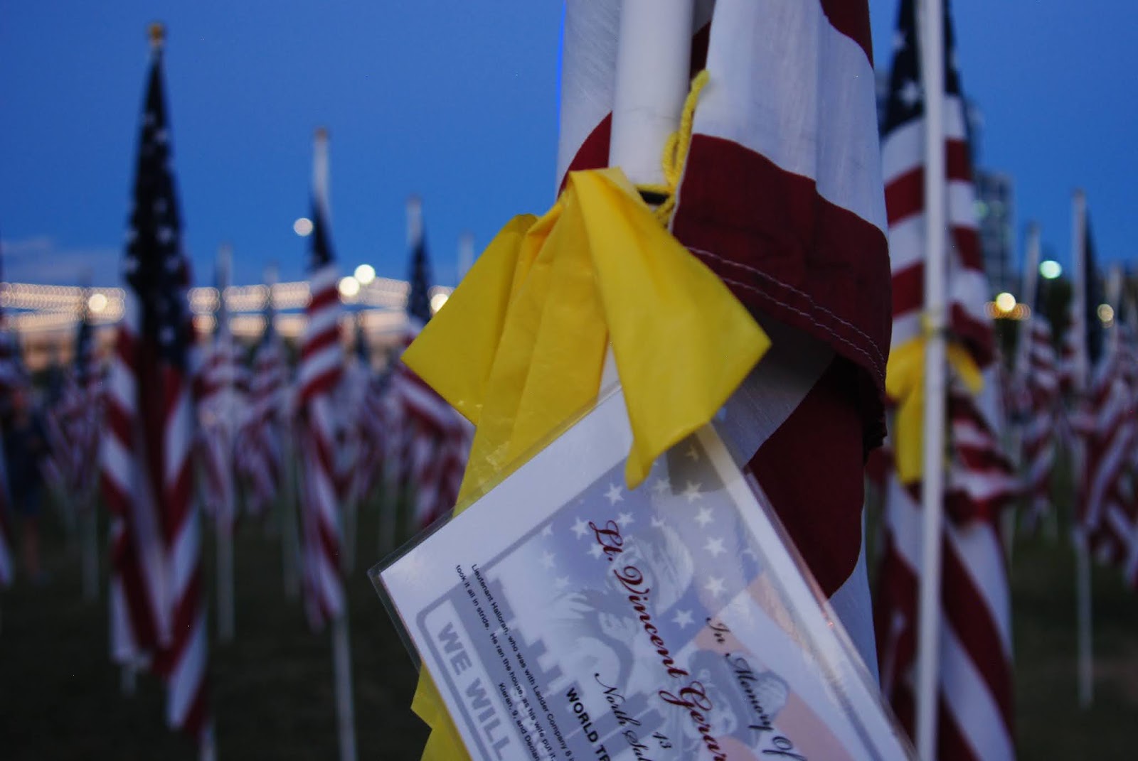
So it's 9/11. 9/11 is emotional for me, as it is for many people - particularly those of us who watched the horrific happenings unfold before our eyes - on tv, in real life, or via the radio. I will never forget sitting on the 26th floor of my office watching the towers fall on the conference room big screen, and watching the airplanes go by our windows and wondering...and crying for my America.
I'm dismayed by the lack of unity in America right now, which makes this 9/11 even more difficult as I see all my old posts about "let's the be America we were on 9/12." I watch the videos, as I always do - this year Bailey came in to watch a few with me. She almost always has done this - she understands why it is heartbreaking for me, although I don't think she feels the heartbreak - the kiddo wasn't even born then. I asked her if her school said anything, and she mentioned that they talked about it during morning prayer and announcements. I was pleased to hear that. Schools have been pulling back on teaching about 9/11 because the students "found it disturbing." Bailey and I usually go to the Healing Fields on 9/11 - but this year it was virtual due to COVID, so we couldn't go. So I watched the videos - and cried - like I always do...
Brandon in his Isuzu Vehicross with Nicole in front
Anyway - so it had been an emotional morning for me, and I wanted desperately to get out of the house. It feels like it's been weeks and weeks. I told Paul I needed to get out of the house and away from work for a bit, and he suggested we go take the 9982 route from Black Canyon City down to Table Mesa Road, then head over to the Black Canyon City overlook. We were taking his truck (the LC - the Lewis and Clark) and I was going to drive at least the 9982 for practice. It's a fairly mild trail - a few slightly off camber spots, but nothing I haven't done before. We had, in fact, just done the 9982 a week or so ago with fellow off-roading buddies of Paul's - Brandon and Nicole of Arizona TREK - to try out Brandon's new-to-him Isuzu Vehicross...which did amazingly well.
So we set off for Rock Springs, where I insisted we stop and get some pie this time at the Rock Springs Cafe - and we popped a piece of mixed berry pie and a piece of Jack Daniel's pecan pie in the ARB fridge for the stop up top at the overlook.
And off we went - we aired down the tires and switched seats. I adjusted the mirrors (cuz I'm short, I guess) and off we went. The 9982 doesn't really have any good opportunities for pictures unless you head over towards Gillette, but we turned off before that. There were a few spots where I got a little nervous - one where we were sliding down a slope in soft dirt, and two where I dropped down one side of the truck into a rut or off a rock and it felt tippy. Every single time - "breathe baby breathe - you're fine" - and I was. The truck did it's thing. All I had to do was steer. Not sure how I'd feel taking Calamity Jane - a manual transmission is just a bit different than driving an automatic, but I feel this would be a good trail for me to practice on. So maybe in the future...
Old broken windmill on the way to Orizaba Mine
Anyway - we turned off the 9982 and headed back towards I-17 to cross under the north and south bound lanes. I was still driving, but was tired, and we were now on a road I'd not been on, so Paul took over driving so I could watch for all the "things." We drove through Moore's Gulch river bottom for a bit, then over to Moore's Gulch ruins - which was overrun with cows, so we just drove through and didn't stop. As Paul has been up here before (and broke the LC too!), we were looking for a mine on an offshoot trail - the Orizaba Mine. It's a little jaunt off the main road (FR46) and as we traveled up the road towards the Orizaba, we stopped to look at this gorgeous windmill. Paul followed some wires up to the top of the hill where he discovered some solar collectors (he told me all about them, but I remember nothing here...) and I took lots of pictures. We forged onward, and found a small tunnel, which of course Paul "had" to go in to - he said it went back about 20 feet or so. He was disappointed. Haha.
And then there it was. The locked gate. To the Orizaba Mine. It was clearly marked Orizaba Mine, and also clearly marked no trespassing. Sigh - always with the closed and locked gates. This gate had electric gate openers, etc., and it looked well used, so like good little off-roaders, we turned around and headed back to FR46.
Paul at one of the Wildlife Water Catchment systems
FR46 is mostly an uneventful road - it travels along quite a few saddles, around a few mountains, then turns and starts heading back towards the I-17 up where the big flat mesas are. Its absolutely stunning country - and it was a beautiful evening. As we bopped along, we discovered cool little things - like a Wildlife Water Catchment system (we found two) with a huge covered water reservoir, and a "watering hole" with a sloped exit point. It was interesting - and informational signs were posted telling us that our tax dollars had purchased the Catchment systems and to please not mess with the cameras. The cameras were missing though. Ha...
Ninja cows on the horizon
As we left the area, we went by an old corral with a shed/covering which we could see from a distance. We passed another watering tank, and then we drove along a ridge for most of the rest of the way.
We passed lots of cows, and we drove and drove on a relatively easy road right up until the end...which must have been 3 or 4 miles from Black Canyon City, but overlooking the city. Watching the lights on the freeway, and watching the sun finally set - Paul and I ate the pie we had brought along, and we watched the lights - we watched the bats start flying, and then it was pitch black - and we decided to head back. It was a quiet night, and nothing strenuous - but it was out of the house and it was off-road with my guy. What more could an AZBackRoadsGirl ask for?
Calamity Jane at the Rainbow Mine over Chloride, AZ
Well, we did it. We scratched up the new skid plates on Calamity Jane. We aired down her tires and scraped and skidded up and down a few mountains to some awesome mines...but I'm getting ahead of myself...
We had been planning a trip to Mohave Lake to go diving for over week. Mohave Lake has a dive park (Cabinsite Cove) and I was really looking forward to taking Paul diving somewhere where he could actually see something. Lake Pleasant being what it is this time of year, the visibility is generally less than 2 feet - and with new divers, it tends to get down to closer to 6 inches.
So we planned to get up and meet some of my dive buddies at 5:15 a.m. to take off to Mohave on Saturday morning. Then on Thursday and Friday everyone slowly backed out - and then it was just me and Paul. So we didn't get up super early - instead we left the house around 7 a.m. and started the long trek towards Mohave Lake/Laughlin. We had decided to stay over night in Chloride - an old mining town that I love, and do a little exploring as up near Kingman is absolutely COVERED with old mines, chutes, towns, etc. Everything Paul and I like to go explore! And we decided to take Calamity Jane this time. Paul grabbed the compressor, we moved the fridge to Calamity Jane, we packed her all up with scuba tanks, gear, food and an overnight bag, and off we went!
The drive to Mohave Lake was uneventful - we cruised up through Wickenburg, circled around Kingman, and drove down towards the Colorado River and Bullhead City/Laughlin. We talked about all the places we had visited up in that area - we reminisced about my suggesting that Paul take Duner (Mike) and Connie to the Hualapai Mansion years ago (more commonly known as the Gold King) and the difficulties he had on that trip - and how cool Paul thought it was. I showed Paul photos of the Hualapai Mansion in 2009 and 2011. I told him of my visits to Chloride and how much I adored the little mining town, and he told me of his visits to other mine sites in the Hualapai Mountains.
It was starting out to be a fun day - and then we got to Mohave Lake. We actually had to wait in line to get in to the Lake - some kind soul on their way out gave us their receipt (good for 7 days) so we didn't end up paying the $25.00 entrance fee - which turned out to be a good thing. As I drove us up to Cabinsite Cove, I never expected there to be hundreds of people parked all willie-nillie there, nor did I expect to see all those people swimming in the cove.
It was 120 degrees out, and I was unwilling to hoof several hundred pounds of gear more than 1/4 of a mile to the water's edge, nor was I willing to leave anything (ie - extra tanks, etc) lying out where anybody could grab it. The park ranger said we could drive down to unload gear, but then had to go park the car in the upper parking lots outside the regular parking area. Too much work, worry and heat.
Hardyville Pioneer Cemetery
So we abandoned the idea of diving, and drove in to Bullhead City to check out an old Pioneer cemetery in Hardyville. It wasn't really worth looking at, and again, it was 120 degrees along the Colorado River. We envied the folks who had their jet skis and were flying up and down the river - and we laughed at a pontoon boat that was FLYING! We decided to head in to old town Kingman to check out the historic district and look for antique stores!
Historic Kingman is tiny - and there weren't many people out (they were apparently ALL at the Lake!). There were some old cars out, and we stopped to walk through a number of antique stores.
Our Nautical Starboard Light
As we walked through them, we discovered a cool old nautical starboard beacon - it was so cool with the blue/green glass and the old brass frame! We snatched that thing up, bought it, wrapped it up good, and took it with us!!! Paul wanted to make a light out of it - and check out how awesome that turned out! We found a red port light on ebay, so we have a matching set!
We then went to a cute little 50's Diner where Paul had his first malted milkshake. We had a good and heavy lunch, then decided to go up the road to Chloride where we were just in time to check in to Shep's Miners Inn - a cute little hotel (the ONLY hotel) connected to a bar and restaurant in downtown Chloride.
Shep's Miners Inn - Chloride, AZ
We checked in to our room - which didn't have any A/C on, so we turned that down, and decided to go out exploring - there were mines close to Chloride we wanted to explore so we headed East up towards the Tennessee Mine (the big one at the base of the Cerbat Mountains) and looped around to the Murals and then started heading up. We decided to air down poor Calamity Jane, because she was bouncing around like crazy - we had a bunch of scuba tanks tied down in the back which made her back end heavy, and airing down took away much of the bounce
Chloride Murals
factor. Calamity Jane and I did awesome - until we came up to an area that had some rock crawls and "sloloms" for lack of a better term. Very rutted out, and up the hill - I got out, hiked to the top, and I thought I was taking a video. As it turned out, I didn't. But I did get to hear Calamity Jane's skid plates hit the rocks But that was okay - even better stuff was to come! After that little bit, the road, while rocky and at times a bit rutted, wasn't terrible. We passed an old ore chute with a huge tailings pile, but we were specifically heading to the Rainbow Mine.
The Saturn and Pickup Truck in the Cerbat Mountains
As we passed around one of the mountains - I said to Paul "hey babe - look at that car on the side of the mountain!" Paul glanced over and said "it's not a car, it's a truck." I looked at him and where he was looking and realized we were looking in two different directions. There was an old truck AND a car both down the side of the mountain (stolen?) not 200 feet from each other. As we finished coming around the bend, the Rainbow Mine came in to site - and what a site! An old building, lots of foundations, ore chutes, mine holes, you name it! Paul and I explored for more than 30 minutes. There was a beautiful breeze, the sun was high up in the afternoon sky, and we were in the kind of place we both love! Mining country!!!
Rainbow Mine Panorama
As we decided to take off, Paul asked me to watch for the car and truck down the side of the mountain. As soon as I saw it, in true Paul form, he scampered down the side of the mountain and hollered back up to me that the car was a Saturn. Paul knows that I used to have a Saturn. He knows I loved it. I loved it almost as much as Calamity Jane - but not quite. I waited to see if he was going to head down to the pickup truck, but he didn't. He came back up, and we headed back down to Chloride to poke around some more.
Cerbat, AZ
Off to Mineral Park - the huge mine South of Chloride. Mineral Park has been around for ages and while I'm not sure they are mining there any longer, it is still secured off. We tried to get to the Mineral Park Cemetery, but it was fenced off with a guard. So we abandoned that idea. Off to Cerbat we went, and while we found Cerbat, we clearly didn't find all of it, and there are a TON more mines we want to go visit up on the East side of Mineral Park.
Santa Klaus, AZ
At this time we realized that the restaurant in Chloride was closed, and we decided to head back to Chloride by way of the minimart. With a quick stop at Santa Klaus. Santa Klaus is a very depressing little stop on the main road to Vegas that has been abandoned for quite some time. We somehow came in from the back side, and got some beautiful photos of Santa's workshop and house. Then we went to the minimart - which was closed.
No dinner for us.
Back to the room we went - now the room temperature was 89 degrees at 3 pm when we checked in. By 8 pm that night, it was 86 degrees. Ugh - it was a long night. The room didn't even get below 80 until about 3 am - and Paul and I both prefer it cold for sleeping...so it made for a rough night.
Old Truck in Chloride that reminded me of Lizzie from the Cars Movie
We got up the next morning, read the news on the spottiest wi-fi ever, and then went over to the restaurant for breakfast. And breakfast was worth waiting for! Excellent bacon and eggs, Paul's steak was flavorful and cooked just right! Endless coffee (for Paul) and hot tea (for me) - and AC. We enjoyed breakfast and discussed the remainder of our day, which would be heading home via a couple of long dirt roads, including Alamo Crossing road and Signal road.
We gathered up all of our things and headed out. We found a Starbucks in Kingman (yay me!), gassed up (yay Calamity Jane) and Paul decided to drive while I navigate. First stop - Yucca, AZ!
Antler Mine Headframe
Yucca AZ isn't much. It has some weird UFO museum there - which we did NOT stop at, although it looked pretty busy. We headed in off the main road towards the Hualapai Mountains so we could head up to the Antler Mine, our first mining stop of the day. Some cool old ranches along the way with old cars, including old Jeeps and an old Kharmann Ghia which looked to be in relatively good shape. It was an easy road - nothing technical - well graded - and we got up there relatively quickly. We found several old buildings and the headframe - explored for a few minutes before discovering that they were actively drilling on the mountain above us, and were watching us. We decided to leave the area, although nothing was posted no trespassing, there's something awkward about being watched out in the middle of nowhere like that.
Next stop up the Boriana Mine Road was a trail to the East that led to the Copper World Mine.
Now Paul has been along this road, and has even been up to
Copper World Mine in the Hualapai Mountains
this mine, however, we discovered on Google Earth a building up there that he said he hadn't seen. He mentioned he had no time to explore the Copper World Mine last time he was up there because people were waiting for him to get back on the Boriana Mine trail. So we aired down Calamity Jane, and did some of the toughest climbing Calamity Jane has seen - yet (the day ain't over!). As we bounced along the short spur up to the Copper World Mine the scenery was beautiful and even though we were on some small shelf roads, not one bit of panic set in! We had to cross numerous wooden "bridges" that went over some small gullies - at first I was nervous, but then realized that the truck could cross the gullies even if the wood wasn't there, so I didn't care if the wood didn't hold...
As we turned the last little bend, the massive structure at the Copper World Mine flotation mill loomed before us. The Copper World Mine was established in 1916 and changed hands many times throughout the years. The mine closed the first time in 1968, then was reopened in 1974 for a very short time, but was closed again shortly after. It is claimed that the Copper World Mine (also known as the Bobcat Mine) has a sizable amount of copper ore still in the ground - enough to make it worth mining. The mine also supposedly has sizable potential for platinum, silver and gold as well! But the road up there is rough and while not long, it is narrow and slow going.
Paul and I were a bit confused about where the building was that we saw on Google Earth, until we were up underneath the flotation mill site - then we saw the little chimney peeking up. While I busied myself picking up sizable hunks of mica (I love mica!!!), Paul scampered up and around to take a look at the explosives building, then up over the tailing pile to the building. As I was surveying the mountain side that the Copper World Mine is built in to, I noted tramway foundations and frames going up the mountain to a higher mine site. What a beautiful site for a mine! And so many goodies to look at - numerous collapsed buildings, contents strewn about the valley, lots of creaking old metal to make it a bit spooky and then the dreaded bees everywhere...we spent quite a bit of time up here just checking it all out. By far my favorite location of the weekend!! The research I did when I got home showed several pictures of the Copper World Mine in its heyday - love finding photos that show how it was and comparing to the photos I'm taking now. This is why I love exploring the old West.
Boriana Mill Ruins
But we still had another mine to go visit - the Boriana - the mine that was supposed to be the highlight of the trip. As we bounced our way back down to the nice and easy Boriana Mine road and turned on to the road, we saw the requisite cows (aka, Ninja Cows). And as we came around a bend, I happened to look up and exclaimed "what's that?" Paul laughed and said "that's the Boriana." It was HUGE! I don't know what I was expecting, but I wasn't expecting that! The site was massive and just hanging out right there on a road that a 2wd high clearance vehicle could make it up to! There were more mill site foundations than I had expected - for once, what I was expecting wasn't anything near what I saw!
Wide view of the Boriana Mine
The Boriana Mine was known prior to 1908, but became a really big deal during World War II as a Tungsten mine. It was, in fact, the largest Tungsten mine in Arizona, but it was closed in 1957 due to a fire. The mine is very extensive and has many, many levels. Most of the mine was flooded in the 1950's, and in 1987, an investigation of the potential of the Boriana concluded that most of the mine had caved in on itself and the rest was filled with hydrogen sulfide gas (note, don't go in it!).
Goldfish at the Boriana Mine
We poked around a bit - then went up to see the highlight of the Boriana - the goldfish pond. Yes, you heard me right - goldfish. They've been up there for years and years - and they are still there! We got out to feed them some goldfish crackers (yeah, we know...cannibals). And we caught sight of a little snake in the water - just hanging out. Then, he caught a fish!!! Amazed by the snake and the goldfish, we stayed at the little pond for probably 30 minutes, then decided to head back down and out of the Hualapai Mountains - we still had to get home and it was getting hot...and we had two more stops to make!
The ride out of the Hualapai Mountains was uneventful. We found Alamo Crossing Road and headed down towards Signal - but had decided to stop at the McCracken Mine. Paul hadn't made it there last time, and I had never been - most of my exploring being on the South side of Alamo Lake and the Bill Williams River.
Rock Cabin at the McCracken Mine Mill Site
Still aired down, the road to Signal was a breeze and super comfortable - barely even felt any washboard at all. We passed the turn off to Signal, and headed down to the turn off for the McCracken. Making jokes about it being the Irish "Release the McCracken" - we bounced our way in towards what the internet refers to as the "Rock Cabin." The McCracken mine was discovered around 1874 and was a silver and lead mine. Mining continued until the 1960's, when the economic viability of the mine played out.
Not knowing what to expect, and thinking that the worst of the four wheeling was done up at the Copper World Mine, we bumped along a little jeep trail until we could see the cabin in the distance. Then the road got a little ominous...Ominous enough that I questioned if we should be going up it in my truck - which is also my daily driver. But Paul's confidence in Calamity Jane overroad any misgivings I had, and up we went. It was by far the worst off-roading Calamity Jane has seen, and we seriously banged up the skid plates - but it was worth it! The "Rock Cabin" had bats, booze, a fireplace, a table, and a mine adit on the outside! It was well worth the trip up, and while I was nervous about going back down (and rightly so - we slid several times), we decided that we had found a cool place to camp someday.
Below the Rock Cabin is the old mill site - best seen from above by the cabin - the McCracken mine itself has adits all over McCracken peak, and there isn't much left at the actual main mine site itself. As we head back out, slipping and sliding along the nasty eroded area and we get back to the "main" road (heavily graded dirt), we head over towards Signal.
Signal Ruins
Now I've always wanted to go to Signal - and was very upset when I heard that the old Bar/Saloon had burned down or was torn down some decades ago. Signal was a large mining center from the 1870’s until the 1930's - by 1932, Signal was quickly turning into a ghosttown...
There are a lot of foundations left in Signal - as well as a substantial cemetery. But a storm was blowing in, and we had to cross a fairly major wash - so we didn't spend a great deal of time here - Signal turned out to be somewhat disappointing for me. But it was getting late - the sun was going down, and we were tired and hungry...so we departed Signal and took the long dirt road back to the 93, and cruised back home through Wickenburg.
A long weekend with some amazing mine finds, and we broke in Calamity Jane good and proper!! Big thanks to Paul for his amazing driving abilities - even in my manual shift! Gotta love a guy who can drive like he does.
Overlooking Sedona and the Red Rock Secret Mountain Wilderness Area from the Mogollon Rim
Phoenix is hot. Too hot. We've been having record breaking temperatures, and it's just miserable. So Paul and I decided to head North this past Sunday and go check out some line cabins north of Sedona. Just for fun. We weren't sure about the roads - we had heard they could be nasty, and we heard that a car could drive them. So we took the VooDoo FJ this time - because Calamity Jane doesn't have much in the way of recovery gear if we were to get stuck.
Sunrise through the smoke haze
The morning started off with an eerie glow to the sun...the California fires and the fires up North are creating a haze of smoke in the Valley and the sun burned bright orange at 6:30 a.m.
As we headed up the I-17, we could see smoke from fires up north, but it was a lovely morning, and it was SO nice and cool up near Flagstaff. We topped off the tank, got some tootsie rolls, and headed down the 89A towards Oak Creek Canyon - turning off just before at Fry Park Road.
Fry Park Road was packed full of campers - huge groups of people everywhere. People getting out of the heat and enjoying the cooler weather - it was a balmy 74 when we turned off on the trail. Lots of quads out bouncing around, cows lying in the sun, and the smell of pine trees! One of my most favorite smells ever! We decided to hit up Winter Cabin first - a cabin that Paul had heard about and had marked on his Google Earth. We knew it would require a small hike. We didn't know how hard it would be - but we were both wanting to get out and move! So we parked at the trailhead, and started down the trail.
Paul headed down Winter Cabin Trail
About 15 minutes in, I mentioned to Paul that we've been going down hill the entire way, which meant up the hill the whole way out...but we were both enjoying the weather, the shade from the pines, the sound of the wind rushing through the tree tops, and the fact that we were the only ones there! The trail wasn't hard, but was severely washed out in numerous places, requiring us to hike along the edge and several times we had to navigate large fallen trees. And some of those trees are BIG! But nonetheless, we pushed on - taking photos of the meadows and the scenery, which was stunning!
Me and Paul on the Winter Cabin Trail
After the 1.2 mile hike in, we finally caught site of the Winter Cabin. I don't have much history on any of the cabins we saw today, except I believe them all to be line cabins, also known as buckaroos, cow camps or simply shelters. These cabins are built by ranch owners to shelter their cowhands while out working on the ranch and away from the main ranch house/bunkhouse. There are lots of them in Arizona, and many are still used today by hikers as shelter during overnight trips.
Winter Cabin Line Cabin - Winter Cabin Trail
The Winter Cabin had a dirt floor interior, but was well built. The old stove out back was all rusted out, and the only thing remaining in the Winter Cabin was an old set of bed springs. The ceiling was low, and the cabin was small. But the setting was outstanding! And there is a smallish spring not far that has a constant source of water - the only one for miles as best I can tell.
Baby horned lizard - we saw a number of these today!
After resting for a bit, we started the trek back out. Well, that hike threw us both for a loop - I knew my lungs were going to have a hard time (asthma and all), plus we are both of of shape. But there was a TON of discussion on the way out, amidst the numerous "we need to rest" stops about getting ourselves in better shape over the upcoming months. But you know what? We made it. It wasn't horrible - and although I had to stop a number of times, we had water, it was cool, there were lots of climbs, but quite a few flat areas too - and shade. All in all, the hike was worth it!
Back at the FJ, we had some Gatorade and snacks, then decided to head down to the next cabin - which we could drive to.
Off we went, down a dirt road that didn't really require anything except maybe a bit of clearance - but I'm not sure that was even necessary until we turned off to actually drive to the Buck Ridge Cabin. We still didn't need 4 wheel drive, but clearance was necessary here.
Original Buck Ridge Line Cabin with the fallen tree
As we came around the last little turn, the Buck Ridge Cabin loomed before us. Along with the MASSIVE tree that had fallen down on it. As we approached the cabin, we could see a newer cabin up the hill, so we started there. Clearly another line cabin, there were bunks with mattresses, an old refrigerator used to store things like notebooks, etc. (not food), a large drum stove, a cool old water pump, and outside there was an outhouse. It was obviously newer, but didn't appear to have been used recently.
Replacement Buck Ridge Line Cabin
I hiked back down to the original Buck Ridge Cabin to take a look at the tree that had fallen on it. The cabin was built much like the Winter Cabin - low roof, small door, one small window. One set of old bed springs still inside - but this massive tree had collapsed most of the roof and one of the walls, necessitating the building of the newer cabin. Paul brought the FJ down and we poked around the cabin for a bit, then decided to head off towards the final line cabin of the day - Hidden Cabin.
We head back the way we came, and then turn off towards Secret Canyon to get to the Hidden Cabin.
Hidden Cabin - note the Hantavirus warning
This little cabin is well preserved. Probably because of the Hantavirus warning posted on the outside wall. And the piles and piles of rodent droppings (which is what hantavirus comes from). This is more of a "home" type cabin than a line cabin - there is a kitchen, a bedroom, and a store room. The bed and mattresses are inches deep in rodent droppings, and while we poked around a bit, we were careful not to stir up any dust or disturb anything. Cute little cabin - but obviously off limits for anything except a quick look/see.
Now we have a nice and easy forest road drive over towards Fernow Cabin (a rental cabin that the Forest Service rents out), and we drove through the northern part of Secret Canyon - a stunning canyon meadow full of ferns. It was the oddest thing to see in Arizona...but beautiful with the occasional pine trees popping up in the middle of millions of ferns. By now it is warmer - but still in the mid-eighties - so it's beautiful out, and again, the scenery is gorgeous!
We pop out on to the main, well graded road that heads up to the lookout tower (our end goal on this road), and we stop to see the Fernow Cabin. It is, of course, closed, so Paul hikes up to take a quick look while I take a short nap in the truck (you know - to guard it! LOL).
Me and Paul overlooking Sedona and the Red Rock Secret Mountain Wilderness area
And off we go again to go up to the lookout towers. Which - as usual - were closed. Sadly we had to turn around, but on the way back out, we decided to stop and take some pictures from the Mogollon Rim overlooking Sedona and the Red Rock Secret Wilderness Park. It was stunning...you could see for miles. We took a number of pictures, and then back to the truck to head out - and we decided to take another side road north which appeared to go to an overlook of Oak Creek Canyon. That little side trip was also well worth it!
As we headed back towards Fry Park Road, and then out onto the 89A, the sun was going down, the cows were all up and wandering around the road and meadows, and the campsites were clearing out - making for a beautiful and peaceful drive out. We aired up the tires, and headed back to I-17 where we had to navigate some major traffic accidents (yay for my navigation skills as well as knowledge of side roads, etc). We finally made it to Black Canyon City where we decided to try Chilleen's having never been. It was decent food - and we were hungry. Which makes for a good combination!
So it's a rare thing when Paul and I both have a full day off - no working from home, no classes to teach, no trucks to fix...
But Thursday was one of those days. So we decided to again do a little something that both of us have done SOME of, but neither of us have seen ALL of. We decided to head up to Dugas Road and off-road in to the Verde River Hot Springs, then head South to Bloody Basin Road, check out a bunch of cabins, and then home.
What a day - a very LONG day...but worth it!
Our day started out at roughly 7:30 a.m. when we left the house in the VooDoo Blue FJ. After a quick stop at Starbucks (because AZBackRoadsGirl loves her green tea in the morning!) we turned on the 50's tunes, and headed North up the I-17 to the musical tunes of Neil Sedaka, Elvis Presley, Pat Boone, and many others! It was a relatively unremarkable ride up - we stopped at Cordes to get cookies (I know, how does the Girl Scout Cookie Mom forget cookies from the roughly 4 cases she still has at home?) and to top off the tank because we knew we were looking at about 87 miles of dirt road run today and wanted to make sure we were good to go!
Side note - I had to laugh because during this huge COVID-19 mess, I, like a good citizen, wore my mask into the store to use the restroom and then get cookies. In the bathroom there are signs posted everywhere about washing your hands. Note you have to hit the button on the toilet to flush it (the auto-flusher wasn't working), the sink was a manual lever you had to pull up and push down to turn on/off. The soap dispenser required touching, and the paper towel dispenser also required touching. Lesson learned here? Always have your hand sanitizer with you!
Paul's Beast - the VooDoo FJ
We settled back into the truck and went the roughly 3 miles up to Dugas Road, and turned off. As soon as we hit dirt, we stopped and aired down the tires. Paul told me there were a few rocky spots, but other than that, the trail should be fairly easy and low key. He forgot about the tight shelf road...that will come in a bit.
We drove across Little Sycamore Creek and through a lovely little ranch area that looked like some kind of old ghosttown - would have been fun to explore if it had been abandoned. Lots of neat buildings...but we had a long drive ahead of us, so on we went...
There were SO many Golden Agave/Century plants in bloom this weekend. The blooms were such a bright and shocking yellow...they were everywhere up off Dugas road - but the forest was dry - tons of yellow, dry grass. We talked about the fire danger, and how many of the National Forests were closing due to fire danger and COVID. In fact, coming up to Sunset Point, the entire East side of the I-17 was scorched - it was sad. I know that fire cleanses the forest and rejuvenates the landscape - but these fires are man made and threatened homes and lives. Be careful people. It only takes a spark...
Ridge at about 7000 ft elevation
We stopped and took some pictures once we reached a ridge - it was absolutely beautiful - the temperature had dropped 15 degrees or more - there was a slight breeze - the views were stunning! We continued to climb up into the "mountains" (I say mountains, but to a Colorado/Wyoming girl, these are hills). And then there it was. A shelf road. A tight one - no room to pass, and occasionally required careful tire placement. In true Paul fashion - before I could even squeak, I heard "Breathe baby, breathe - just look at me - don't look at the edge. We've got this!"
And he was right. After a slight hyperventilation moment, I settled in and while I didn't look down, I was able to enjoy the switch backs and some of the fun sights. The worst part of the trail all day was on the switchbacks - it's a place where Paul has shredded a tire before. But he navigated the boulders like a champ - and we dropped over the steps like they weren't even there. Gotta say I'm always impressed with my guy's driving abilities - and his truck. He makes it look easy.
The old Datsun
And then we came around a switchback and Paul pipes up "there's the old Datsun." I was like "what are you talking about?" And there it was, an old Datsun sedan that had gone over the edge, being held up by several trees. Made me feel better about the switchbacks. If we roll down the mountain, those trees are pretty strong! (Note to self - stop with the extreme worst case scenario planning Bobbi - WTH?). And also in true Paul fashion, he scales down the side and goes poking around the car. I stayed with the FJ. You know, in case it decided to drive away on its own...
We continue through the shelf road, and come up to the "T" in the road that we plan to take south AFTER we go to the hot springs. Right there at the "T" is a newer Chevy truck - we aren't sure why it's there, but we continue on - until we hit the locked gate.
The abandoned Chevy
Now we've been having a lot of bad luck with locked gates lately. We are less than a mile from the hot springs and we can't get in. Sign says there is a camera. So we turn around and head back to the "T" in the road because we figure we will try coming in from the southern route - which has traditionally been gated for the last few years, but we figured we'd give it a try. This is how we went from 87 miles of dirt to more than 100...
At the "T" we stop to look at the truck because we notice bullet holes in the side mirrors. The truck has clearly been abandoned. The Forest Service has put an abandoned notice on the window. The radio has been stolen, as has the battery. The truck is a bit of a mess, but has clearly been there for a bit. But there's nothing of interest, so we take off south towards the big power lines, which is where our turn off to attempt another route to the hot springs is located.
Houston Creek
On the way, we pass this beautiful little area on Houston Creek - it's all lush and green - Houston Creek is running - its quiet and gorgeous. It would be an absolutely lovely place to camp...and still nobody on the trail. Not a soul.
We make it to the turn off, and we start heading in towards the Verde River again. We follow the massive power lines for a ways while Paul explains about the voltage, the insulators, arcing, etc. Most of it is over my head, but I enjoy listening to the explanation of these enormous power structures that I see all the time but have never much thought about. A short shelf road and a few rocky spots later, and we get to the gate. It's open. Paul gets out to see if it's been forced open or purposely unlocked. We weren't able to tell, but because it was open, we went in...and in five minutes or so, we are at the Verde River. We were at a wide portion of the river, but we weren't sure of the depth, so Paul goes out to see how deep it is. He makes it across with the water only being thigh deep. But I'm not overly comfortable with crossing the river, then knowing we have to cross it again further up. So we park the truck on a little trail, eat some light lunch, then start hiking up the trail towards the hot springs.
Now - note at this point - I've not been drinking much water today, and I only ate veggies for lunch - no meat or anything substantial. It's hot out. And we are bushwacking our way up to the hot springs on the west side of the river. We come to a point where we can no longer go up the river and we HAVE to cross. I'm starting to over heat, and I realize my blood sugar is dropping (thank you hypoglycemia). I didn't pack any granola bars, and only two bottles of water. I change from my hiking boots to my Teva's (for water), and tentatively put my toes in the river (which felt nice after the little walk).
View of the Hot Springs Resort from the
former footbridge footing
So Paul coaxes me across the river - with the patience of Job - and makes me sit down and drink one of the bottles of water. He hikes ahead a bit to see where we are, and comes back like 4 hours later (it was actually only 8 minutes - he timed it - but it felt like forever - and all the animal noises. I'm certain they were eyeing me as food. LOL). I'm feeling better - there's been a nice breeze, and Paul tells me that after a 4 minute hike we will be able to see the old resort across the river.
Paul in the "swim hole" - aka the Verde River
As we hike up what is clearly part of the Verde flood plain, we come upon a couple of cairns, and we take the little trails to what is clearly one side of the old footbridge across the Verde. We can see the resort!! Now I'm excited and I can't wait to get over there...so we continue up the east side of the river, and we come upon this HUGE swim hole right next to where we cross the river. The river crossing, by the way, is ankle deep and maybe 15 feet across. Total breeze. But we decide to swim for a bit - cool off and enjoy the solitude of being the only two people up there for miles and miles.
Paul in one of the hot spring pools
After we've both cooled down, we hike over to the hot springs - which smelled - not like sulfur, but something else. It wasn't pleasant. We investigate the caves, the two soaking pools, and we hop in for a quick soak - but not for long. The water is hot, and the weather is hot - not the best combination. And we are both wanting to go back and swim in the swim hole. We take our photos - laugh at some of the "art" and sayings painted all around, and head back and jump in the swim hole.
After a nice, cooling swim, we discuss our route back - and decide to go up to the Childs Power Road that heads to the old Childs Hydroelectric Power Plant which we saw bits and pieces of as we hiked up to the hot springs. It's an easy walk up a road and down past the plant - but the plant is fenced off, so we weren't sure if we would be able to get down to the dispersed camping area (where Paul originally crossed the river and where we intended to cross back). The fence was down at the Childs Plant, so we got to see some of the plant up close, although it is boarded up and you cannot get in.
Childs Hydroelectrical Facility Building
The Childs-Irving Hydroelectrical Facility was named an Historical Mechanical Engineering Landmark in 1971 and was added to the National Register of Historic Places 20 years later. It was decommissioned in 2005 and no longer produces power. Much of the complex has been removed in order to allow Fossil Creek and the Verde River to return back to their natural habitat. Built in 1908 by Arizona Power Company (the precursor to APS), the complex provided power to mining communities in the Bradshaw Mountains and Black Hills.
The Verde River where we crossed (on foot) by the
Childs Dispersed Campground
Paul and I cross the Verde River at the Childs Dispersed Campground (closed) and got back to the truck, realizing that it's 5 p.m. already, and we still have more than 50 miles of off-road trail to complete - with a couple of stops along the way. We start heading out - still haven't seen a single person since we turned off the highway - and we head South on FR57 towards Bloody Basin Road.
As we make our way down towards Bloody Basin Road, we stop a few times to look at cabins, or another abandoned car complete with some sort of nest in the engine compartment (a Kia Sorento?? How did that even get out here...). The closer we get to Bloody Basin Road, the faster we can go as the road goes from a two track jeep trail to a well graded and maintained ranch road. We go through places like "Yellow Jacket Canyon" - which we decided to avoid due to - well - yellow jackets.
One of the Cabins
And then Bloody Basin Road came in to sight, and
we knew any difficult driving was over. We've both been down Bloody Basin
Road numerous times - but there were some cabins we wanted to explore.
Arizona has a number of old ranch cabins that are out in the wilderness that
owners, hikers, horseback riders, and the like leave stocked and ready for
visitors. People are welcome to stay there - you take what you need,
leave a little for the next person, keep the place clean. Many of these
cabins run in lines along what would be a cattle or sheep herding operation -
and are spaced fairly regularly. Bloody Basin Road has a number of these
- and we visited quite a few. Some are easier to get to than others -
some are blocked off and there are no trespassing signs (we stayed away from
those). I'm not giving any additional information as to the whereabouts,
but I will post some pictures here of our find.
Another dilapidated cabin
Bloody Basin Road is the only place we saw signs of humans the entire day on the dirt - one side by side, one pick up truck, and one cattle trailer/truck. It was a perfect day - just how we like it - me, Paul, an FJ and nature.
Final cabin of the night
As we were heading out of the Agua Fria National Monument area, we found Bloody Basin Road blocked off. We skirted the barriers and read the signs on the other side - Bloody Basin Road/Tonto National Forest is closed due to extreme fire danger and COVID-19. We came in through Prescott National Forest, and of course had no idea when we had moved into Tonto - but we took only pictures, left only footprints - so we were good.
As soon as we saw pavement, we stopped to air up the tires. And we were starving for something more than just veggies and cheese - so I started looking for something to eat on the way home. It was 9:20 on a Thursday. I suggested RockSprings Cafe - closed. Then Chileen's - closed. Denny's in New River? Closes at 10 p.m.
So we went to In-n-Out, ate in the truck, then scooted on home...we were exhausted. It was a long day - but it was amazing - Paul, a VooDoo FJ Cruiser, 100+ miles of dirt, a hot spring, and several historic cabins! No better way to spend the day - gotta love Arizona!
Me and Paul - Verde River Hot Springs Resort Ruins