Showing posts with label Calamity Jane. Show all posts

Wednesday, December 23, 2020

Box Canyon and Martinez Canyon - AZFJ Christmas Meet Up

Lewis & Clark and Calamity Jane - Price Road, Florence, AZ

This past weekend Paul and I combined the AZFJ.org Christmas Meet Up with a chance to wheel in, then hike in, to Martinez Canyon - one of my favorite places to go in Arizona.  So far, in my opinion, one of the top 5 most beautiful spots in all of Arizona!  Even more beautiful now because there is no motorized traffic allowed in there.  

But as usual - I'm getting ahead of myself.  

So everyone knows we have two FJ's.  Calamity Jane - mine - she's Black Cherry Pearl (also known as purple) and Lewis & Clark - Paul's - Voodoo Blue.  They are both 2007, mine is a manual, Paul's is an automatic.  Both have a lift, although Paul's is higher than mine - Paul's has been very seriously outfitted for off-roading, while mine has just started the process!  But we NEVER take them both out together.  Paul and I enjoy different aspects of off-roading - Paul loves the challenge of driving, I love watching the maps and keeping on the look out for buildings, etc on the way - we both love what we call "destination" driving.  We rarely go off-roading "just to go drive on a dirt road."  There's almost always a cabin or a mine we have researched to go see.
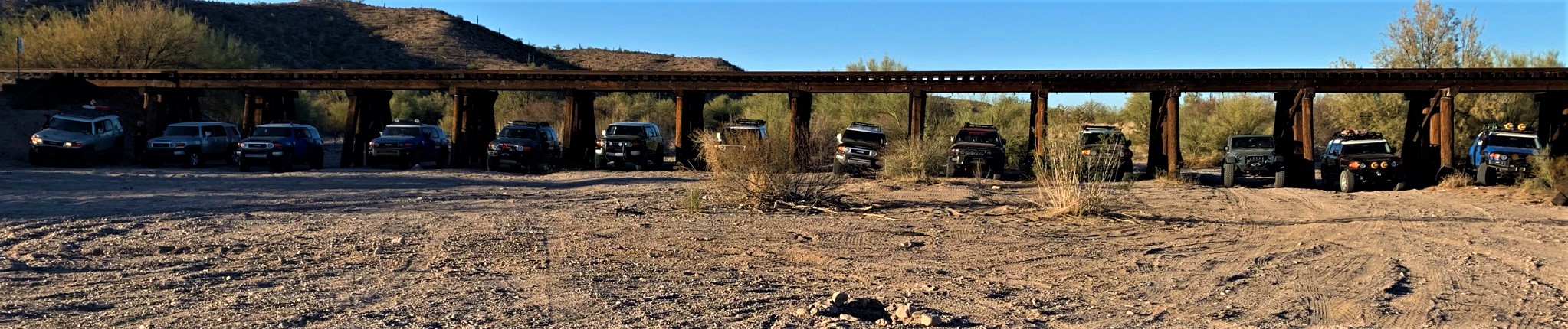
AZFJ Crew - Price Road, Florence, AZ

So when www.azfj.org said they wanted to go "run the box canyon" for Christmas - I told Paul we should go - and take both trucks (because hey - people are always surprised to find out we have two) and then go camp out and hike to Martinez Cabin/Mill/Mine in the morning.  Paul agreed!  We got the ham radios set up so we could chat along the way (that's the biggest thing I missed about riding with Paul - I love the conversation - which doesn't happen the same when you're in separate trucks).  We fixed a few suspension things on Lewis & Clark, made sure both girls were ready to romp - and on Saturday afternoon, off we went.  

Our trucks with their Christmas lights

We wanted to arrive a bit early - we were meeting at the shooting area outside of Florence - but past that a few miles is the train bridge - an old wooden train bridge with spots just wide enough to put an FJ Cruiser in!  So Paul and I took Lewis & Clark and Calamity Jane and took some photos of the girls.  Calamity Jane has her new bumper on with two of Lewis & Clark's KCHilites HID lights on the front.  She's looking particularly bad-ass, although still a bit shorter than Lewis & Clark.  After taking photos and admiring our trucks (because hey - who wouldn't - they look awesome!), we head back to the shooting area to meet up with the other AZFJ folks.  Our friends Bryan and Kelly were there, Alicia (who I know from Lady Owned Toyotas), and several others.  From 3-4 we all chatted, took pictures of the trucks, and just re-acquainted ourselves with old friends - some of whom we have known online for 7-8 years!

At 4 p.m., we all decided to head out.  Because Paul and I have ham radios, and only one other truck had ham (Ray - the route leader), we headed up the back of the group.  Besides, we were going to peel off and head to Martinez Canyon after the box canyon was finished - so we figured being in the back was best.  

Entrance to the Box Canyon - Gorgeous Country!

So a line of 13 trucks start heading up to the Box Canyon - and what a beautiful afternoon/evening it was.  Some of us had our Christmas lights on our trucks - all of us looking awesome in perfect FJ style!  The Box Canyon was easy enough.  Only one small area did I need a bit of spotting - our good friend (and amazing glass guy - if you need his info, hit me up!), Bryan Glider, spotted me up and over a rock obstacle, which Calamity Jane handled like a champ!  Paul was behind me and said I handled it perfectly!  I was still waiting for the dreaded "waterfall" - but it was not to be on Saturday night.  

The trucks - with lights - at camp

As we exited the Box Canyon and headed up to the Stage Stop, Paul and I agreed that we would turn around and head back to the Martinez Canyon turn off.  Neither of us realized the Waterfall was further up Mineral Mountain Road...but now we knew we would be handling it alone - just the two of us - on Sunday morning.  So we left our group of AZFJers to find a camping spot for the night.  

Paul had me lead - although my phone's GPS was having difficulty - the road was fairly obvious and we had both been to Martinez Canyon before (although Paul had not been all the way back to the mill).  We found a lovely little camping spot just off the road, we set up our nice little Marmot tent, built a small fire, and made dinner.  We had decided to just do freeze dried food this weekend - so we both had Mountain House Beef Stroganoff Adventure Meals.  We get these at Wal-Mart, and they aren't half bad!  Although I got a kick out of commenting on whether the meal was the adventure, or you ate them on your adventure (I'm easily amused).  Anyway - Paul fixes us both a drink, and we sit back by the fire enjoying the cold air, the amazingly clear sky with stars, and the warmth of the fire.  

Our Kamping Keurig - the OXX

And then we turn in for one of the worst nights sleep I've ever had.  Now, we had cots - so we aren't sleeping on the ground, and we have Paul's Buddy Heater, so I should have been super-comfortable.  I slept well until 1 a.m., then I got cold.  And I couldn't get comfortable in the down mummy-bag.  So I tossed and turned, and finally got up and went and got in Calamity Jane, started her up, started up her heater, and turned on some soft music and dozed off for an hour or so.  I should mention that Paul slept like a rock!  

So bad night's sleep aside, I got up around 6:30 as the sun was coming up, and started poking around the fire remnants trying to get a new fire started from the buried coals.  I hear Paul from inside the tent "babe - is that you?"  I laughed - asked him who he thought it was.  I heard something about big foot...crazy guy.  He comes out and gets the fire good and started, and we get out our totally awesome Oxx CoffeeBoxx - an industrial strength Keurig - Paul fires it up, and in no time, we have hot coffee and tea in our cute little Yeti Ramblers (Paul's is orange, mine is teal).  We sit around by the warm fire just enjoying the hooting of a bunch of owls, then the squawking of some other bird who seemed perturbed by our presence.  It was quiet.  Not a soul in site - nobody had come down the road, and we were in the middle of nowhere quietly enjoying the beauty of Arizona.  We had another round of Mountain House Adventure Meals for breakfast - not as good as my eggs and bacon, but certainly easier - then we pulled up camp, and headed out for the last 1.5 miles of road to where we park our trucks for the hike in to Martinez Canyon.

Adventure Meals...

So a short bit of history here - back in 2010, I went to Martinez Canyon on the quads after visiting the Coke Ovens (which are now off limits) - you can see this in an old blog post of mine.  We were able to take the quads all the way up to the Mill if we chose - although I stopped just past Martinez Cabin as I was tired of fighting with the quad at the time and it had been a really long day - we hiked the rest of the way in (maybe half a mile from the cabin to the mill).  Sometime before 2017, they closed Martinez Canyon to all motorized traffic.  Probably not a bad thing - there were some gnarly off-road trails up there (ie - "The Luge") and the road was getting very torn up and the trestle from the mill across the river bottom had fallen.  I saw the trestle before it fell - but Paul didn't.  When Paul went in 2017 with Duner and Connie, they had to park and hike in as the road had been closed by then.  From Martinez Cabin, they took the wrong path - they went up The Luge path - but gave up and went back.  To get to the Mill, you keep going up the river bottom.  So I've been to the Mill, but Paul has not - I was so excited to show it to him!
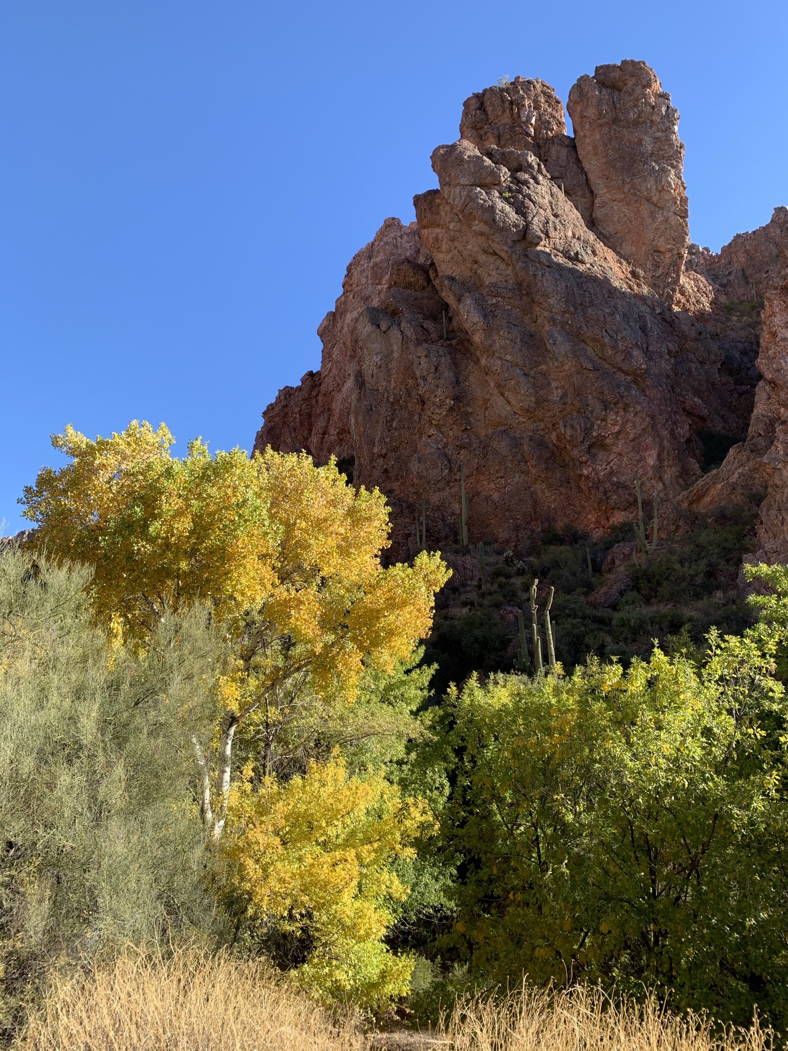
Martinez Canyon
Our little campsite


As we head out on foot, my new Osprey pack on my back, we hoof it down a rocky, but relatively well maintained road into the river bottom.  Then it becomes a little less clear.  Sometimes there is a road.  Sometimes there is a trail.  Sometimes there is just a river bottom.  But heavens is it beautiful in there.  The trees have all changed colors, the canyon walls are bright orange and red with the sun - such a gorgeous place for the hard life of mining.  The road has all but deteriorated by this point - and looks nothing like a road - and nothing like I remember it.

As we approach Martinez Cabin, I'm dismayed, as I usually am when I revisit old sites, to see how degraded it is.  There are entire buildings missing.  The old generators have been dragged out from their shed covering and stripped of copper wiring.  The Cabin itself is rotting away - and will soon fall over due to a tree that has grown/fallen into it.  I cannot count that as human caused, so I'm less upset about that - but the rest of it is clearly human caused damage.  Lack of respect, greed and downright lack of caring about our pioneer history.  This will all be gone someday...with only memories and people's photos to remember it by.

Martinez Cabin in Martinez Canyon

Paul checking out a small adit

After we poke around the cabin site area for a bit, we head up and over to the Mill.  The road is even less obvious - and where there is a road, it is so badly washed out that it looks too dangerous to even hike on.  We chose to hike up the small trail next to the creek.  I can't believe I took a quad up here...but I see where we stopped due to a Jeep with broken tie rods, as well as a rock garden full of baby heads.  This is, by the way, where I coined the term "baby heads."  Head sized rocks that make for uncomfortable wheeling.  Uncomfortable, not impossible.  However, this road is now pretty much impossible/impassable.  The washouts are massive, and the boulders are huge.  

As the canyon opens up, we can see the smoke stack of the Mill - I'm of course saddened by the lack of the trestle, but excited to show Paul all the machinery inside the Mill itself.  We scramble up the side of the river banks to the mill, and I get bummed out again - it seems a great deal of stuff is missing.  The site has been stripped of anything that can be reasonably carried out, and only the massive pieces of machinery are left.  The parts bins, which used to be full of old parts, are empty.  Copper has been stripped off of anything it can be stripped from.  But the large equipment - its amazing.  Paul is, as always, mesmerized by all the things that can be flipped, turned or switched.  He's like a 5 year old.  But his engineer nerd comes out as he explains to me (whether I'm listening or not, I should add) what everything does.  

Martinez Mill - 2010

Martinez Mill - 2020

The Martinez Mine operated from 1880 until 1971 - so it has a long history - not all of it old.  It was a lead, silver, copper, gold and zinc mine.  It used to be owned by a family in Florence, but is now on BLM land.  It has several known adits, and is also known as the Silver Bell - Martinez Mine and sometimes the Columbia-Silver Bell Mine.  The lower adit/shaft is flooded at the bottom, and is dangerous to enter (as are most mines in Arizona).  

Paul and I stop to have a snack in the shade of the old Mill, then we hike the very short way up to the mine adit - due to the steep incline, Paul opts not to go in (and after watching some YouTube videos, I'm glad he didn't - it's flooded).  But we decide it's time to head back, as we still have to tackle a major 4 wheeling obstacle on the way out - The Waterfall.

The hike out of Martinez Canyon was uneventful, but beautiful.  The drive out to Mineral Mountain Road was bouncy but easy.  We followed several pick up trucks up towards the Waterfall, and I'm trailing behind so as not to suck so much dust, when Paul comes over the Ham and says "there's a Jeep up here.  And a 4Runner.  Oh, and this must be the Waterfall.  Wow - it's worse than I thought it would be."

Martinez Canyon - the old road up

And I just stop Calamity Jane for a second.  I still haven't seen the Waterfall.  I was already scared.  I've seen video.  I'm not even sure my truck can make it.  But I drive forward as a manual shift Jeep takes a line up the obstacle - flexing more than I've ever seen a vehicle flex, and I look at Paul and tell him there's no way.  My truck can't make it, and there is no way I'm doing it.  The lady in the 4Runner says she's not going up it - she doesn't have skid plates or a lift, and she explains the alternate route around.

But of course, because a Jeep has done it, Paul is going to do it in Lewis & Clark.  And he takes the harder line straight up.  Scares the living daylights out of me - I'm certain he's going to slide and get body damage - I call over someone who helped spot the Jeep for help - but Lewis & Clark climbs it like the boss she is, and as he drives by me (as seen in the video), he says "Now we just have to get yours up here."
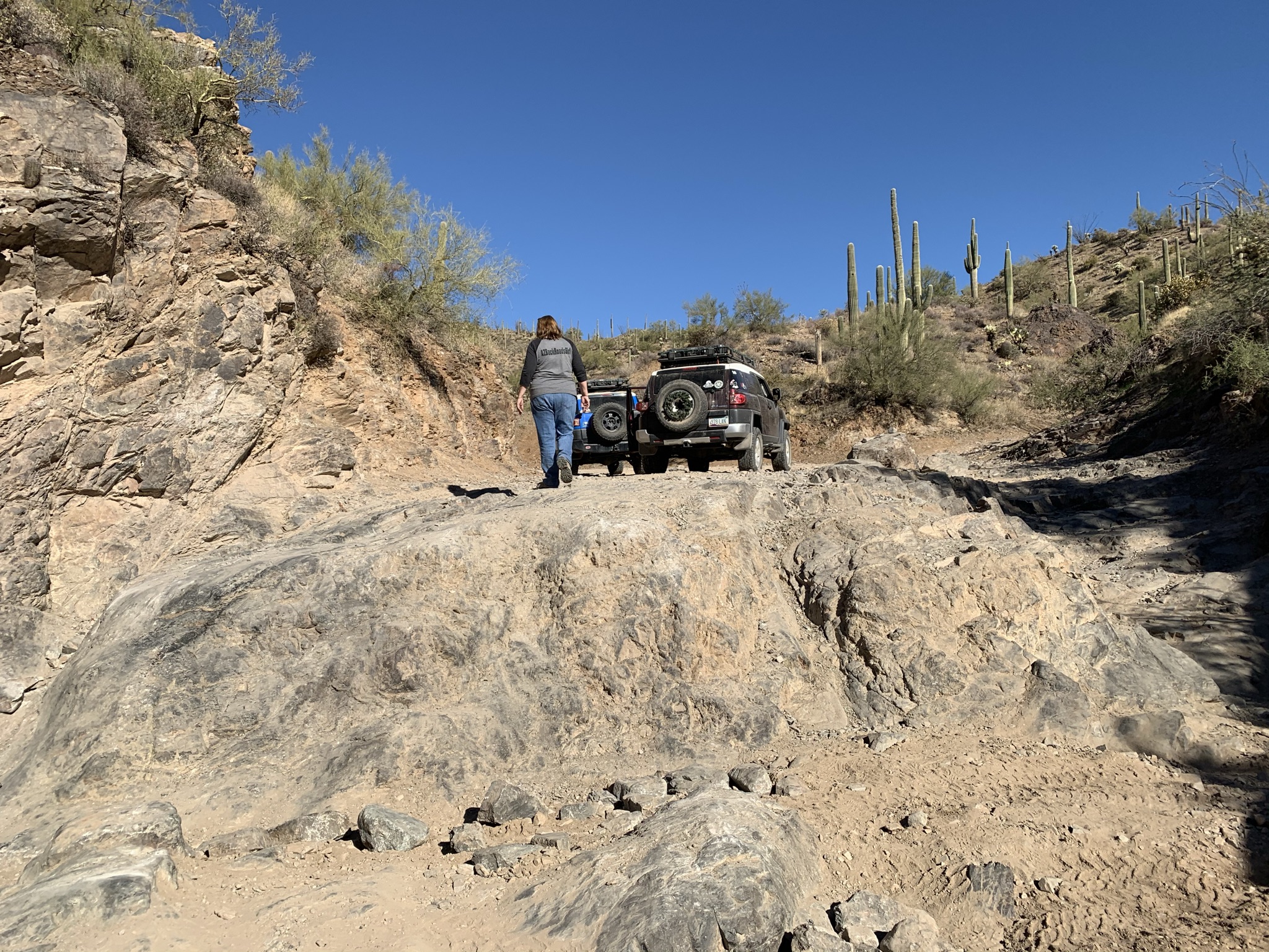
The top half of The Waterfall obstacle

So Paul takes Calamity Jane, and brings her up.  She stalls a time or two - as expected.  But she popped right up and over those nasty rocks.  I had no idea she could rock crawl like that.  Still not sure I'd have tried it - definitely not in a manual - but it did give me a ton more confidence in Calamity Jane.  The videos don't do this obstacle justice.  Paul was frequently on 3 wheels, and half way up, I thought Calamity Jane was gonna need a winching.  But her tires caught, and up she popped - like the bombshell she is!  These trucks can do anything with the right driver!!  Which is apparently not me.  Haha.  But seriously - look at her bad ass go up that obstacle - those rocks are 3-4 feet high!  And as soon as your front tires are over those rocks, you can't see anything but sky.  Paul did it with a big smile on his face.  Crazy.  He's crazy.  Gotta love him though.  Here are the video links...

Paul's Truck - Lewis & Clark - Part 1


Paul's Truck - Lewis & Clark - Part 2


Bobbi's Truck - Calamity Jane - Part 1


Bobbi's Truck - Calamity Jane - Part 2


The rest of the drive out was long, but uneventful.  I was tired - lack of sleep and stress over the Waterfall had taken it's toll - but it was beautiful country, and I had fun driving my truck.  As Paul said, all I needed was a little "seat" time to feel what she can do.  And while I may not have done the Waterfall, I did everything else without panic and without tears.  So all in all, it was a good trip!

Two FJ's - Twice the Fun!


Tuesday, November 24, 2020

KofA National Wildlife Refuge - Cabins, Mines and Beautiful Mountains

Calamity Jane at Skull Rock in the KofA National Wildlife Refuge

Six years.  It's been six years since I was in the KofA/Castle Dome Mountain area.  Six years since I visited the Big Eye Mine with Bailey - and Paul!  Yes - it was Paul and my second outing in April of 2014 - we had Duner and his family along, as well as Alex.  But this time - it was just me and Paul - and Calamity Jane with her new shocks (Bilstein 5100) and lift (Toytec)!  It was an AMAZING day!

Lewis & Clark, Calamity Jane, Alex's Jeep and Duner's FJ
in April of 2014 at the entrance to the KofA

This trip was planned sort of last minute - we had a number of destinations we were trying to go see, and had to make a choice as to where we were going to go.  Because we decided to scuba dive on Saturday, we only had the one day - so we chose to go to the KofA, which is short for the King of Arizona - a group of mining claims south of Quartzite and north of Yuma on the 95.  Paul and I had previously been to the Castle Dome Mountains (Big Eye Mine) in 2014, which is closer to Yuma than where we went this time - but I remember just loving the rugged looking mountains - they remind me somewhat of Red Rocks in Colorado - they jut up at odd angles, and just come rising up out of the desert like some underground hand just pushed them up and out of the Earth's crust.  I love it out here.  In addition - the KofA region of Arizona is one of the earliest mining areas in the entire state.  It is bordered by the Colorado River, so back in the mid to late 1800's when the Colorado flowed of it's own accord and we had steamboats on the river, this area was a lucrative settlement for people.   The KofA and Castle Dome Mountains are, in my opinion, some of the prettiest in the state - challenged only by the beauty of the Chiricahua's in the southeastern portion of Arizona.  

KofA National Wildlife Refuge
We meant to start out early.  We always do, but we slept in, then laid around reading the news and having coffee and tea.  But then we packed up my new turquoise Canyon Cooler with drinks, snacks and icea, and off we went to start the 2 hour drive to Quartzsite where we would top off Calamity Jane and head south on the 95.  

Our first stop was at a group of mining claims - some of which are on private property and are not accessible, some of which are on the KofA refuge.  I will not be giving specifics on these mines because of the pristine condition in which a number of them remain.  But wow - we started out our day strong - and it was by far one of the coolest stops we've ever made!  

One of the Cabins at our first stop
As we explored our first stop, we discovered several cabins, a workshop, a machine shop, and an amazing mill/processing building which was remarkably intact.  Several engines which ran a number of different portions of the operation were found, and Paul was able to explain how almost everything worked.  It was fascinating seeing how the different buildings were tied together with pulleys and following the lines we were able to figure out how things ran from the mill/processing building right down to the machine shop. We discovered a HUGE drill press, which Paul works in the below video - we were surprised that a) it was still there and b) it still worked quite well!  This was also run by a belt (the belt is no longer there) powered by some of the engines in the mill/processing building.  

Old flathead 6 Chrysler Industrial engine

Paul loves to tinker - and he will dig around and explore even more than I will - he will go places I won't go - but he always knows when I'm going to regret not seeing something - so he climbed steep and rickety stairs, came back and got me, made sure I went up to see all the "things," and when we exited the main mill/processing building, he went up to look at another shed, and came back to get me because he knew I wasn't going to want to miss it - the actual mine adit.  He was right - every single thing I saw just continued to amaze me!  I don't think either Paul or I have been to a site so perfect since back in 2014 when we visited another amazing mining site in the middle of the state with Bailey and my brother.  We spent several hours at this mining complex - and we plan to go back soon.  

It always amuses me how interested Paul is in all these old workings.  I'm fascinated just by the amount of stuff - but Paul is interested in how it works.  When we got home from this particular trip, Paul must have spent 2 hours researching this Flathead 6 Chrysler Industrial engine - he found videos of what it would sound like, he found a marine version, and he played every single video (and made me listen to most of them!  Ha).  And then he spent hours researching a Servel gas refrigerator we saw up there.  

O'Keefe Merritt Stove/Oven combo
I do a different kind of research - I researched the stove/oven combos we found, kitchen appliances, some of the books found in the cabins, and the history of the mine - I love to read about what kind of minerals were found, when they were found, who owned it and when, and the timeline of the mine as well.  Together, Paul and I spend HOURS researching after our trips - the hours we spend together learning about where we just were makes my heart just burst - I've never explored with someone who had as much interest in not just the off-roading to get there, but the actual history of the people and place itself!  

But - in true Paul and Bobbi Jo form, we had several other places to visit as well!  Including the famous Skull Rock.  So we left the mining district we were in, and headed back to the 95 to go up to the Queen Palm Canyon area to find Skull Rock.

Calamity Jane in front of Signal Peak

Now Paul was the one that knew about Skull Rock - and we plan to go back.  It's a VERY cool rock formation - it wasn't difficult to get to although you are in a wash for more than half the drive (so be careful if you go during a storm).  Here, though, the scenery was amazing.  Beyond amazing.  Stunning is a better word for it.  We kept stopping to take photos of the mountains.  Well, and of my truck.  Because hey - she has new shocks, a lift and new bump stops (all thanks to Paul).  She didn't bottom out once - and the ride is so much smoother than it was.  And hey - she looks awesome 3 inches taller!  Paul and I both noticed a big difference in the comfort of the ride on washboard and just bouncing around.  Best improvement in a long time!  

Bobbi Jo at Skull Rock
Skull Rock has been used as a camp site for years - and in fact, when you are standing inside the base of the rock itself, it smells heavily of fire - it does make some amazing photos when you have this ghostly skull with fire coming out of its mouth staring out of the dark desert at you - that will have to be another trip, however.  

Behind Skull Rock is a very tall, vertical rock which is balanced on two smaller rocks - you can actually see through the area underneath that tall rock.  Again - the rock formations here in KofA are just amazing!  Paul and I poked around for a bit, but realizing we had other things to go see, we again headed out towards the 95 and went up to another trail...

Box Canyon on tbe way to De La Osa Well

This next trail was a bit rougher in a few spots - but we never once hit my BudBuilt skid plates!  And we bounced along for quite a long ways all while looking for the De La Osa Ranch cabin.  Well - we were in for a surprise.  Apparently, a watershed covering and a cabin look exactly the same to me on Google Earth.  So I repeatedly said to Paul (who is driving) "who the heck puts a ranch cabin all the way out here and the road is so bad?"  

Hmmm - well, we got out there and turns out it is the De La Osa WELL.  Not cabin.  Or ranch.  Absolutely no idea how I came up with it being a ranch.  Paul was mildly amused by my mistake.  Mildly.  But the windmill was in excellent condition, and we were originally going to go up to High Tank 8 to check out the watershed up there, but it was getting late and we had a VERY long drive out - and still more to see!  So we started to head back to the 95, but then decided to change our route and head overland to the Kofa Cabin.  We turned off back the road right outside the Box Canyon and headed northeast.  
De La Osa Windmill

This route was long, and while not terribly rough, there were a TON of washes as we crossed through the KofA Wildlife area on designated roads (you aren't allowed to be on roads that are not designated roads).  The washes were generally the kind of washes that you "drop" down in to, and then climb out of on the other side.  Lots of sand and dirt, and by this time, it is pushing 4 p.m.  We wanted to be done looking at all of the "things" no later than 5, because we knew once we were done at the Kofa Cabin we had about an hour drive out, and we weren't sure the quality of the El Paso Natural Gas Company Access Road we were going to follow out.  

Kofa Cabin

The desert was beautiful, and just as we popped out of the last wash and I mentioned that GaiaGPS  (our number one choice for off road mapping and navigation) showed us close, we could see the Kofa Cabin!  Now the Kofa Cabin was built by the Civilian Conservation Corps ("CCC").  The CCC was made up primarily of young Native Americans from the Colorado Indian Tribes Reservation, and they built not only this cabin, but several earthen and rock reservoirs in the KofA area, including the Four Peaks Dam in the late 1930's.  This cabin is exceptionally well constructed of basalt stone, and is open to the public for camping on a first come, first serve basis.  

After a quick exploration of the Kofa Cabin, we head out on to the El Paso Natural Gas Company Access Road (longest road name ever) and start the long trek back out to the 95.  Approximately a 25 mile drive on a graded dirt road with nothing much to see except tons and tons of gas pipeline signs, we finally exited the KofA National Wildlife Refuge, aired up Calamity Jane's tires, and headed back in to Quartzsite.  It was time for some dinner, so we found a cute little cafe off the beaten path in Quartzsite - the Mountain Quail Cafe.  Awesome burgers, and great service - if you get a chance - go there!  Well worth it!!

We had full tummies, a full tank of gas, and a 2 hour drive home.  It was dark, we were tired, but we were still so happy about our day, the findings at the mining complex, and just the fun of getting out while it's so nice in Arizona!  The KofA didn't disappoint - it didn't in 2014, and it didn't in 2020.  We look forward to coming back soon!
Desert Labyrinth on the way to Palm Canyon in the KofA


Monday, May 18, 2020

Mica, Mountains, and Murder - Big Reef Mill

Big Reef Mill Site
So Sunday late afternoon - I had to work until 4 - but Paul and I had plans to go check out the Big Reef Mill after work - a location I discovered on Google Earth and then considered checking out on my Easter drive on the Castle Hot Springs Road - but didn't.  The Big Reef Mill (also called the Green Dragon Mine) was a mica and beryllium mine.  Not mica like the lovely large slabs - but mica that could be crushed for commercial purposes.   They crushed it into mica dust and sold it for quite a bit of money.  This mine was prosperous - until misfortune befell the owner...

So Paul and I left the house - we were hungry and wanted to grab some In-n-Out before we did the Castle Hot Springs loop.  We left the house without my Nikon, without extra water, and without a gun.  Basically unprepared.  Not really like us, but oh well...  

We stopped at In-n-Out, had cheeseburgers while maintaining social distance from all the other patrons, jumped back in Calamity Jane and we were off! 

The trail to Castle Hot Springs was uneventful, except this picture, which struck me as incredibly funny.  I had to jump out to take a photo of it.  Note the sign, which reads:  

"No Fishing or Cliff Divin'"

Someone has a good sense of humor...
After having a good laugh the sign and the tiny little stream, we pressed onwards.  We passed Castle Hot Springs, the JL Bar Ranch and barn, and continued on through the roughly 15 miles or so of Castle Hot Springs road - it was beautiful - the canyon you drive through was absolutely stunning and it was tempting to stop and poke around a bit, but we were also chasing the sunset, and wanted to get to the Mill site.  

As we approached the first turn off from the East, I explained to Paul that I wasn't sure the road was passable because it didn't look so good on Google Earth - although it looked awesome from where we were sitting in the truck.  We drove down the road to the point where it turns to go down in to the river bed, and we stopped - Paul got out to see what the road looked like and he said it was about an 8 foot drop straight down (ie - Calamity Jane would be nose first in the river bed).  So, we backed out, retraced our steps to Castle Hot Springs Road, and turned into the river bed.  This route proved to be successful!  We put Calamity Jane in Low to get her up a little bit of an obstacle - spun the tires for a bit (found out later we were only on 3 tires!), caught hold, and up we bumped.  

Chute of some kind

We parked up by the large concrete pad in front of the Mill ruins, and both of us were exclaiming "look at that" or "look over there" - and we both took off.  In different directions!  Paul beelined for the old twisted, shot up, burned up car ruins, and I took off up the road to see where it went.  

Old Jeep


As Paul and I independently hiked around looking for things, and trying to shoo off the flies (they were horrible out there), Paul discovered that the vehicle was a Jeep - and it had been burned and shot all up.  I couldn't even recognize it for anything except some sort of vehicle - but Paul figured out relatively quickly that it was a Jeep.  


From the top of the chute, overlooking Big Reef Mill and the Bradshaw Foothills
The Crow
I ended up on the top of the Mill site overlooking the Bradshaw Mountain Foothills (yes, again...I know).  Stunning vistas, and the sun was starting to go down which made all the colors just pop.  Paul joined me up top and as we were taking picture and looking around at various roads and paths heading off into the mountains, a large crow came and landed on the tower.  The crow didn't move again the entire time we were there.  


Paul and I walked the road back down as the sun began to set, and as usual in the Bradshaws, all the colors began to change and turn to hues of purple and pink.  
Panoramic Shot from the Top of Big Reef Mill


As we walked back to Calamity Jane, we wondered about the history - as we always do - of this cool old site. Well, thanks to some early morning digging on Paul's part, and diligent reading on mine, we discovered some odd things about this awesome site just rusting away in the mountains.

The crow is still on the tower
In 1959, Doc M. ("Dee") Cantwell purchased 21 claims and the surrounding land and began to test the area for mica and beryl crystals.  By 1964, Cantwell is actively mining his claims, and is producing and selling plenty of mica and beryl.

In 1965, Cantwell starts considering selling or leasing his claims to anyone else...numerous other companies and people express interest, and in 1966, Cantwell has a mining examiner out to review the claims due to a potential lucrative deal with a California group. Cantwell continues to work the property until mid-1966, when the gates are locked and nothing appears to be going on any longer.  

At this point in the research, I can't figure out exactly what happened, except that in 1967, Joe Wong and some associates claim they have taken over the Big Reef Mill and begin to work it.  At this point, I have no idea what happened to Mr. Cantwell - there is no indication that he sold his rights - but now Wong Associated Enterprises appears to be mining the claims and building on the plant.    It is at this time that I find the small note at the bottom of one of the mining examiner's pages that Mr. Cantwell, manager and owner of Big Reef Mill, is in the County jail on three counts of attempted murder at Big Reef Mill.  This is in October of 1967.  

The mill changes hands a number of times, and as recently as 1988, mining was still consider to be a possible lucrative endeavor at Big Reef.  No other mention of Cantwell, and I can find absolutely nothing about him online anywhere.  I'm sure the public court records in Yavapai County don't go back that far, but I did look - nothing.  This will be an ongoing project for me - as I'd really like to know what happened to Mr. Cantwell.  He did not get put in the State Prison System, as those historical records came up with nothing.  


So with nothing else to think about except the beauty of the Bradshaws, Paul and I head back out towards Castle Hot Springs Road.  I took a video of the "rough" spot we hit going up.  Doesn't look so nasty coming back down (just let gravity bring you down....).  But its fun to see Calamity Jane doing her thing.  

So until next time, stay cool my Phoenix friends - it's hot out there!

Paul at the base of the Mill terraces