 |
| Crossing the border from New Mexico into Colorado - Welcome to Colorful Colorado! |
At the end of August and beginning of September, Paul and I decided to head up to Ouray, Colorado to tackle a trail that holds a great deal of fear for me...Black Bear Pass. If you have read any of my previous blog posts, you know I'm not good on shelf roads. I mean, I'm NOT good...I'm terrified of heights and I'm worried about going over the edge. For good reason - today I read in an Ouray paper about 3 folks who passed away outside of Camp Bird at Drinking Cup outside Ouray this past weekend. Paul assures me the road is not difficult (right) and just has a steep drop off as it switchbacks its way from Bridal Veil Falls and the Smuggler-Union Hydroelectric Plant down to Telluride.
 |
| Highway Flowers in Bloom in Northern Arizona |
Paul's oldest boy, Brandon (@3gfinn), and his lovely new wife Julia met us for our second night with their awesome Tacoma, and stayed in Ouray and ran trails with us through Wednesday. Paul and I left on Saturday morning, intending to make it to our campsite by Saturday before dark. And we made it!
 |
| Shiprock, NM |
The drive to Colorado was mostly uneventful. Lots of beautiful flowers along the way, and of course, we got to see Shiprock rising majestically out of the New Mexico high-desert.
 |
| Wild Deer in Colorado |
We saw lots of deer on our way to our campsite - we chose to stay up by the Portland Mine in a wildland camping spot. It was quiet, although not entirely secluded. There were other folks staying around us every night we were there, but they were at enough of a distance to not matter and not disturb. But our views - oh my goodness they were awe-inspiring! Just look...
 |
| View to the East from our base camp |
 |
| View to the South from our base camp |
We arrived at camp in the late afternoon, set up camp, skipped dinner (we had a big lunch), and went to bed in the superbly cool temps! We had our new ExPed mats, and we slept like a couple of logs through the night!
 |
| Our Camp Above Ouray, CO by the Portland Mine |
On Sunday morning, we woke up to lovely, cool temperatures...the sun doesn't crest over the mountains until about 10 a.m., so we had a lovely and relaxed breakfast, and then we decided to go into town, check everything out, and maybe shop a bit.
 |
| Ironton, CO - one of the two story homes |
We went down to the Visitor's Center, and spoke with some ladies who informed us that under no circumstances should we try Black Bear or Imogene, and absolutely DO NOT go down Poughkeepsie. These ladies indicated that the trails were so badly damaged from recent rain and landslides that they were flat out dangerous for anyone. Paul didn't think anything of it (he's done all these before), so we explored a bit in town, and decided to go check out some ghosttowns that were close to the road and not around the trails we were planning to take.
 |
| Another two story house in Ironton, CO |
So off to Ironton we went. Down the Million Dollar Highway (US Highway 550). With me on the cliff side. Sigh...
 |
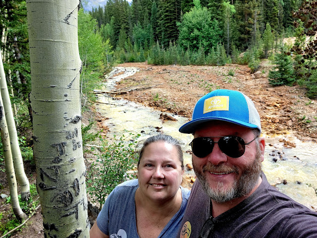
| Me and Paul on the Red Creek on the edge of Ironton, CO |
The Million Dollar Highway was originally constructed as a toll road in the 1882 by Otto Mears and Fred Walsen. In 1920, the road was updated again and the path you now take is the one that was built in 1920. I've heard three stories as to why it is called the Million Dollar Highway - the first, being the cost to build it back in the 1880's, the second being "you'd have to pay me a million dollars to drive that road" and third, because of the Million Dollar Views.
 |
| Another old house at Ironton, CO |
I don't care why it was named - it's a road that affords stunning views, as well as terrifying drops right off the side of the blacktop. The Million Dollar Highway has no guard rails, and when I looked into why, I learned that in order for the snow to be plowed in the winter, they have to be able to push it off the edge. So no guard rails. This road has around 40 accidents per year, with 7 fatalities per year on average. I'm not overly fond of this road, but I've been on it before, and I'm sure I'll be on it again. Access to some of the most beautiful places in the San Juan mountains is right off of the Million Dollar Highway.
 |
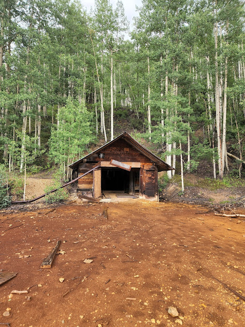
| The Larson Brothers Mine outside Ironton, CO |
So as we heading down the road towards Red Mountain Pass, we stopped just short of it to see Ironton. Once called Copper Glen, Ironton was first started in 1893. Shortly after, there were more than 300 buildings in town. Ironton was a major transportation junction between Red Mountain and Ouray in addition to having some of it's own mines. The town was heavily populated throughout the first part of the 20th century, and the final resident of the town, Milton Larson, died in the mid-1960's.
 |
| The Snow Shed over the entrance to the Larson Brothers Mine |
There were several beautiful old buildings there. Such a difference in how Arizona chooses to preserve history and how Colorado preserves their history. It was such a change to see full homes with roofs (albeit patched) and obvious work to keep buildings standing and safe. We saw this all over this area, and it made our visit incredible as there was TONS to see!
 |
| Inside the Snow Shed at the Larson Brother's Mine - Ironton, CO |
After Ironton, Paul and I headed back to camp as it had started raining, and we were awaiting Brandon and Julia's arrival. So back to camp we went...
Part 2 - Black Bear Pass - to come...
 |
| Me and Paul waiting out the rain/hail storm at the Larson Brothers Mine Snow Shed - Ironton, CO |


